

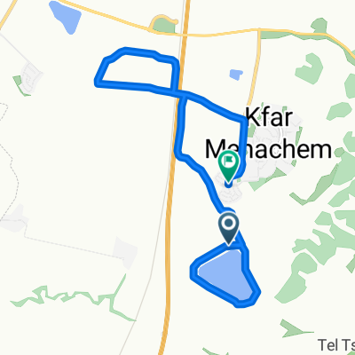
סובב חצב 2
A cycling route starting in Bnei Ayish, Central District, Israel.
Overview
About this route
סובב חצב במסלול הפוך וקצת שונה - מסלול יותר מהיר ויותר כיפי
- -:--
- Duration
- 13.8 km
- Distance
- 73 m
- Ascent
- 73 m
- Descent
- ---
- Avg. speed
- ---
- Max. altitude

Continue with Bikemap
Use, edit, or download this cycling route
You would like to ride סובב חצב 2 or customize it for your own trip? Here is what you can do with this Bikemap route:
Free features
- Save this route as favorite or in collections
- Copy & plan your own version of this route
- Sync your route with Garmin or Wahoo
Premium features
Free trial for 3 days, or one-time payment. More about Bikemap Premium.
- Navigate this route on iOS & Android
- Export a GPX / KML file of this route
- Create your custom printout (try it for free)
- Download this route for offline navigation
Discover more Premium features.
Get Bikemap PremiumFrom our community
Other popular routes starting in Bnei Ayish
 11 קמש
- Distance
- 10.9 km
- Ascent
- 169 m
- Descent
- 198 m
- Location
- Bnei Ayish, Central District, Israel
 סובב קרית מלאכי
- Distance
- 28.1 km
- Ascent
- 117 m
- Descent
- 113 m
- Location
- Bnei Ayish, Central District, Israel
 14 קילומטר
- Distance
- 14.1 km
- Ascent
- 171 m
- Descent
- 191 m
- Location
- Bnei Ayish, Central District, Israel
 От Ha-Nitsakhon Street 64, Bnei Ayish до Altalef Street 4, Yehud
- Distance
- 35 km
- Ascent
- 62 m
- Descent
- 65 m
- Location
- Bnei Ayish, Central District, Israel
 Haruvit Forest and Britain Park
- Distance
- 42.1 km
- Ascent
- 391 m
- Descent
- 390 m
- Location
- Bnei Ayish, Central District, Israel
 סובב חצב מעודכן 3.4.2018
- Distance
- 13.6 km
- Ascent
- 75 m
- Descent
- 77 m
- Location
- Bnei Ayish, Central District, Israel
 ראם - עמק האלה - לוזית - תימורים
- Distance
- 71.2 km
- Ascent
- 459 m
- Descent
- 459 m
- Location
- Bnei Ayish, Central District, Israel
 Relaxed route
- Distance
- 10.4 km
- Ascent
- 189 m
- Descent
- 207 m
- Location
- Bnei Ayish, Central District, Israel
Open it in the app