

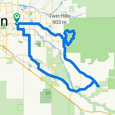
Gates pass McCain loop road
A cycling route starting in Tucson, Arizona, United States.
Overview
About this route
Ride Description
This is a popular bike ride on the west side of Tucson, Arizona. You pass Old Tucson and the Desert Museum along the ride.
There are some great views at the top of Gates Pass. Stop and take a look to the east and to the west.
The ride has a little of everything: flats, rollers, and a short killer climb up the back side of Gates Pass.
To add mileage you can do McCain Loop several times or in reverse to add variety.
Many people park at University and Euclid at the UofA entrance. Or you can park at the top of Gates Pass or Old Tucson for a shorter ride
- -:--
- Duration
- 48.6 km
- Distance
- 526 m
- Ascent
- 525 m
- Descent
- ---
- Avg. speed
- ---
- Max. altitude

Route quality
Waytypes & surfaces along the route
Waytypes
Quiet road
8.8 km
(18 %)
Access road
2.9 km
(6 %)
Surfaces
Paved
18 km
(37 %)
Asphalt
12.6 km
(26 %)
Paved (undefined)
5.4 km
(11 %)
Undefined
30.6 km
(63 %)
Continue with Bikemap
Use, edit, or download this cycling route
You would like to ride Gates pass McCain loop road or customize it for your own trip? Here is what you can do with this Bikemap route:
Free features
- Save this route as favorite or in collections
- Copy & plan your own version of this route
- Sync your route with Garmin or Wahoo
Premium features
Free trial for 3 days, or one-time payment. More about Bikemap Premium.
- Navigate this route on iOS & Android
- Export a GPX / KML file of this route
- Create your custom printout (try it for free)
- Download this route for offline navigation
Discover more Premium features.
Get Bikemap PremiumFrom our community
Other popular routes starting in Tucson
 bike tour through Tucson
- Distance
- 16.7 km
- Ascent
- 38 m
- Descent
- 40 m
- Location
- Tucson, Arizona, United States
 Hi Corbitt
- Distance
- 11.7 km
- Ascent
- 19 m
- Descent
- 24 m
- Location
- Tucson, Arizona, United States
 Tucson, AZ - Mount Graham, AZ
- Distance
- 245 km
- Ascent
- 2,723 m
- Descent
- 769 m
- Location
- Tucson, Arizona, United States
 Steady ride in Tucson
- Distance
- 16.1 km
- Ascent
- 35 m
- Descent
- 36 m
- Location
- Tucson, Arizona, United States
 Nicks
Nicks- Distance
- 5.3 km
- Ascent
- 11 m
- Descent
- 48 m
- Location
- Tucson, Arizona, United States
 East Timrod Street 4343, Tucson to East Timrod Street 4343, Tucson
- Distance
- 8.3 km
- Ascent
- 22 m
- Descent
- 25 m
- Location
- Tucson, Arizona, United States
 Fast ride in Tucson
- Distance
- 45.6 km
- Ascent
- 165 m
- Descent
- 165 m
- Location
- Tucson, Arizona, United States
 2012-Apr-29 Pinarello Dogma
- Distance
- 86.5 km
- Ascent
- 541 m
- Descent
- 541 m
- Location
- Tucson, Arizona, United States
Open it in the app