

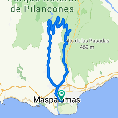
GC-Mogan-Soria-Maspalomas
A cycling route starting in Maspalomas, Canary Islands, Spain.
Overview
About this route
- -:--
- Duration
- 83.8 km
- Distance
- 1,320 m
- Ascent
- 1,319 m
- Descent
- ---
- Avg. speed
- ---
- Max. altitude

Continue with Bikemap
Use, edit, or download this cycling route
You would like to ride GC-Mogan-Soria-Maspalomas or customize it for your own trip? Here is what you can do with this Bikemap route:
Free features
- Save this route as favorite or in collections
- Copy & plan your own version of this route
- Split it into stages to create a multi-day tour
- Sync your route with Garmin or Wahoo
Premium features
Free trial for 3 days, or one-time payment. More about Bikemap Premium.
- Navigate this route on iOS & Android
- Export a GPX / KML file of this route
- Create your custom printout (try it for free)
- Download this route for offline navigation
Discover more Premium features.
Get Bikemap PremiumFrom our community
Other popular routes starting in Maspalomas
 Playa del ingles - Tal der Tränen
- Distance
- 121.9 km
- Ascent
- 3,008 m
- Descent
- 3,008 m
- Location
- Maspalomas, Canary Islands, Spain
 Light Gran Canaria
- Distance
- 52.6 km
- Ascent
- 2,320 m
- Descent
- 2,192 m
- Location
- Maspalomas, Canary Islands, Spain
 EL TABLERO-JUAN GRANDE
- Distance
- 18.4 km
- Ascent
- 124 m
- Descent
- 204 m
- Location
- Maspalomas, Canary Islands, Spain
 04. Grand Canyon
- Distance
- 40.3 km
- Ascent
- 579 m
- Descent
- 579 m
- Location
- Maspalomas, Canary Islands, Spain
 Maspalomas (Mogan)
- Distance
- 105.8 km
- Ascent
- 1,726 m
- Descent
- 1,725 m
- Location
- Maspalomas, Canary Islands, Spain
 st.lucia
- Distance
- 80.2 km
- Ascent
- 1,207 m
- Descent
- 1,210 m
- Location
- Maspalomas, Canary Islands, Spain
 los palmitos
- Distance
- 28.4 km
- Ascent
- 480 m
- Descent
- 552 m
- Location
- Maspalomas, Canary Islands, Spain
 Maspalomas - Fataga - St. Lucia - El Doctoral - Maspalomas
- Distance
- 74.9 km
- Ascent
- 1,234 m
- Descent
- 1,234 m
- Location
- Maspalomas, Canary Islands, Spain
Open it in the app