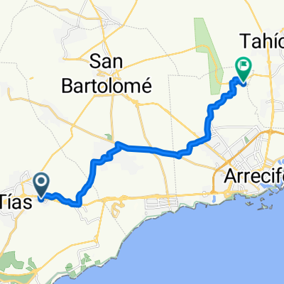
Lanzarote - 80km - 900 hm - La Santa
A cycling route starting in TĂas, Canary Islands, Spain.
Overview
About this route
- -:--
- Duration
- 81.2 km
- Distance
- 839 m
- Ascent
- 839 m
- Descent
- ---
- Avg. speed
- ---
- Avg. speed
Route quality
Waytypes & surfaces along the route
Waytypes
Busy road
45.2 km
(56 %)
Road
11.1 km
(14 %)
Surfaces
Paved
59.6 km
(73 %)
Unpaved
4.2 km
(5 %)
Asphalt
59.2 km
(73 %)
Gravel
2.7 km
(3 %)
Continue with Bikemap
Use, edit, or download this cycling route
You would like to ride Lanzarote - 80km - 900 hm - La Santa or customize it for your own trip? Here is what you can do with this Bikemap route:
Free features
- Save this route as favorite or in collections
- Copy & plan your own version of this route
- Sync your route with Garmin or Wahoo
Premium features
Free trial for 3 days, or one-time payment. More about Bikemap Premium.
- Navigate this route on iOS & Android
- Export a GPX / KML file of this route
- Create your custom printout (try it for free)
- Download this route for offline navigation
Discover more Premium features.
Get Bikemap PremiumFrom our community
Other popular routes starting in TĂas
- die Haria Tour
- Distance
- 91.6 km
- Ascent
- 982 m
- Descent
- 981 m
- Location
- TĂas, Canary Islands, Spain
- Die Mirador del Rio Tour
- Distance
- 91.6 km
- Ascent
- 986 m
- Descent
- 975 m
- Location
- TĂas, Canary Islands, Spain
- Die Playa Blanca, Nationalpark, Nazareth, Areciffe und zurĂĽck Tour
- Distance
- 104.4 km
- Ascent
- 860 m
- Descent
- 862 m
- Location
- TĂas, Canary Islands, Spain
- Lanzarote - 87 km - 870 hm - SĂĽden
- Distance
- 86.8 km
- Ascent
- 830 m
- Descent
- 833 m
- Location
- TĂas, Canary Islands, Spain
- Zentraltour Lanzarote
- Distance
- 30.8 km
- Ascent
- 285 m
- Descent
- 288 m
- Location
- TĂas, Canary Islands, Spain
- Die Puerto del Carmen, Orozola, Je, Haria, Tabayesco, Teseguite, Teguise,Conil, Puerto del Carmen Runde
- Distance
- 129 km
- Ascent
- 1,293 m
- Descent
- 1,124 m
- Location
- TĂas, Canary Islands, Spain
- Die Femes, Playa Blanca, El Golfo, Nationalpark, Nazareth und zurĂĽck Tour
- Distance
- 107.2 km
- Ascent
- 891 m
- Descent
- 891 m
- Location
- TĂas, Canary Islands, Spain
- Kanári szigetek 1. nap
- Distance
- 20.4 km
- Ascent
- 358 m
- Descent
- 110 m
- Location
- TĂas, Canary Islands, Spain
Open it in the app