

5. Etappe (nachgebaut)
A cycling route starting in Vienne, Auvergne-Rhône-Alpes, France.
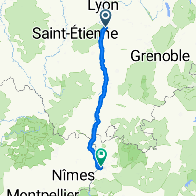
Overview
About this route
- -:--
- Duration
- 121.4 km
- Distance
- 88 m
- Ascent
- 116 m
- Descent
- ---
- Avg. speed
- ---
- Max. altitude

Route quality
Waytypes & surfaces along the route
Waytypes
Cycleway
60.7 km
(50 %)
Quiet road
27.9 km
(23 %)
Surfaces
Paved
77.7 km
(64 %)
Unpaved
7.3 km
(6 %)
Asphalt
76.5 km
(63 %)
Loose gravel
4.9 km
(4 %)
Continue with Bikemap
Use, edit, or download this cycling route
You would like to ride 5. Etappe (nachgebaut) or customize it for your own trip? Here is what you can do with this Bikemap route:
Free features
- Save this route as favorite or in collections
- Copy & plan your own version of this route
- Split it into stages to create a multi-day tour
- Sync your route with Garmin or Wahoo
Premium features
Free trial for 3 days, or one-time payment. More about Bikemap Premium.
- Navigate this route on iOS & Android
- Export a GPX / KML file of this route
- Create your custom printout (try it for free)
- Download this route for offline navigation
Discover more Premium features.
Get Bikemap PremiumFrom our community
Other popular routes starting in Vienne
 14 Etap Tdf Vienne - Avignon
- Distance
- 206.1 km
- Ascent
- 409 m
- Descent
- 562 m
- Location
- Vienne, Auvergne-Rhône-Alpes, France
 3- Villefranche-sur-Saône - Vienne
- Distance
- 71.2 km
- Ascent
- 140 m
- Descent
- 270 m
- Location
- Vienne, Auvergne-Rhône-Alpes, France
 Vienne->lac de Paladru
- Distance
- 63.6 km
- Ascent
- 734 m
- Descent
- 400 m
- Location
- Vienne, Auvergne-Rhône-Alpes, France
 Vienne - Rive-de-Gier
- Distance
- 99 km
- Ascent
- 1,651 m
- Descent
- 1,566 m
- Location
- Vienne, Auvergne-Rhône-Alpes, France
 vienne- valence
- Distance
- 87.8 km
- Ascent
- 135 m
- Descent
- 178 m
- Location
- Vienne, Auvergne-Rhône-Alpes, France
 Recovered Route
- Distance
- 4.3 km
- Ascent
- 114 m
- Descent
- 63 m
- Location
- Vienne, Auvergne-Rhône-Alpes, France
 8.Tag Fahrradspendenmarathon 2016
- Distance
- 132.6 km
- Ascent
- 167 m
- Descent
- 255 m
- Location
- Vienne, Auvergne-Rhône-Alpes, France
 Rhone-Vienne-south
- Distance
- 280.2 km
- Ascent
- 1,486 m
- Descent
- 1,568 m
- Location
- Vienne, Auvergne-Rhône-Alpes, France
Open it in the app