

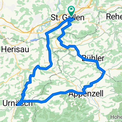
Appenzeller Route Nr 42
A cycling route starting in St. Gallen, Canton of St. Gallen, Switzerland.
Overview
About this route
Die Appenzeller Route führt von St. Gallen zuerst ins Appenzeller Hinterland nach Stein. In Stein befindet sich die Appenzeller Schaukäserei und das Volkskunde Museum. Erleben Sie, wie der würzige Appenzeller Käse produziert wird und tauchen Sie ein in frühere Zeiten. Anschliessend führt die Tour nach Appenzell, dem kleinsten Kantonshauptort der Schweiz. Es lohnt sich, vom Velo abzusteigen und durch die berühmte und malerische Hauptgasse zu schlendern. Die Tour führt weiter via Sammelplatz nach Gais. Der schmucke Dorfkern ist eine Augenweide und lässt manch Photografenherz höher schlagen. Stets ein wenig aufwärts geht’s nun, bis man den St. Anton erreicht. Von hier aus geniessen Sie die einmalige Aussicht übers Appenzellerland und ins Rheintal. Inmitten der typischen Appenzellischen Streusiedlungen fährt man weiter durchs Vorderland nach Walzenhausen, dem «Balkon über dem Bodensee». Die grandiose Aussicht bleibt Ihnen nun auf dem ganzen nächsten Abschnitt via Wolfhalden nach Heiden erhalten. Entdecken Sie das Biedermeierdorf, zum Beispiel mit einem Besuch des Henry-Dunant-Museums. Die Rundfahrt endet in St. Gallen, welches man über Rehetobel – Speicherschwendi erreicht.
- -:--
- Duration
- 69.1 km
- Distance
- 1,255 m
- Ascent
- 1,257 m
- Descent
- ---
- Avg. speed
- ---
- Max. altitude
Route quality
Waytypes & surfaces along the route
Waytypes
Road
33.9 km
(49 %)
Quiet road
20.7 km
(30 %)
Surfaces
Paved
47 km
(68 %)
Unpaved
1.4 km
(2 %)
Asphalt
47 km
(68 %)
Pebblestone
0.7 km
(1 %)
Continue with Bikemap
Use, edit, or download this cycling route
You would like to ride Appenzeller Route Nr 42 or customize it for your own trip? Here is what you can do with this Bikemap route:
Free features
- Save this route as favorite or in collections
- Copy & plan your own version of this route
- Sync your route with Garmin or Wahoo
Premium features
Free trial for 3 days, or one-time payment. More about Bikemap Premium.
- Navigate this route on iOS & Android
- Export a GPX / KML file of this route
- Create your custom printout (try it for free)
- Download this route for offline navigation
Discover more Premium features.
Get Bikemap PremiumFrom our community
Other popular routes starting in St. Gallen
 St. Gallen Heiden
- Distance
- 32.7 km
- Ascent
- 812 m
- Descent
- 811 m
- Location
- St. Gallen, Canton of St. Gallen, Switzerland
 Rundfahrt St. Gallen - Gübsensee - Hundwil - Stein - Riethüsli - St. Gallen CLONED FROM ROUTE 170310
- Distance
- 25.1 km
- Ascent
- 478 m
- Descent
- 476 m
- Location
- St. Gallen, Canton of St. Gallen, Switzerland
 SG- Gäbris-Hohe Buche- Waldegg
- Distance
- 30 km
- Ascent
- 825 m
- Descent
- 825 m
- Location
- St. Gallen, Canton of St. Gallen, Switzerland
 13.03.11 Sitter Tour
- Distance
- 39.8 km
- Ascent
- 650 m
- Descent
- 650 m
- Location
- St. Gallen, Canton of St. Gallen, Switzerland
 appenzellerrundfahrt
- Distance
- 48.9 km
- Ascent
- 833 m
- Descent
- 768 m
- Location
- St. Gallen, Canton of St. Gallen, Switzerland
 Rosenberg Trail erweitert
- Distance
- 21.3 km
- Ascent
- 500 m
- Descent
- 500 m
- Location
- St. Gallen, Canton of St. Gallen, Switzerland
 St. Gallen MTB Tour T1
- Distance
- 34.7 km
- Ascent
- 436 m
- Descent
- 433 m
- Location
- St. Gallen, Canton of St. Gallen, Switzerland
 Day 4 - St. Gallen to Konstanz
- Distance
- 58.9 km
- Ascent
- 115 m
- Descent
- 391 m
- Location
- St. Gallen, Canton of St. Gallen, Switzerland
Open it in the app