

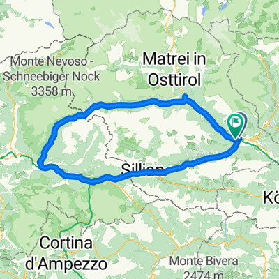
Giro dell'Alto Adige Südtirol 2018 - stage 4
A cycling route starting in Lienz, Tyrol, Austria.
Overview
About this route
Lienz - Iselsberg - Winklern - Dollach - Heiligenblut - Kasereck - Guttalbrücke - Kaiser-Franz-Josephs-Höhe - Hochtor - Fuscher Törl - Edelweisspitze - Hochtor - Heiligenblut - Apriach - Winklern - Iselsberg - Lienz
Iselsbergpass (1204 m)
Kasereck (1930 m)
Kaiser-Franz-Josephs-Höhe (2369 m)
Hochtor (2505 m)
Fuscher Törl II. (2428 m)
Fuscher Törl I. (2407 m)
Edelweisspitze (2571 m)
- -:--
- Duration
- 138.6 km
- Distance
- 3,284 m
- Ascent
- 3,284 m
- Descent
- ---
- Avg. speed
- ---
- Max. altitude

Route quality
Waytypes & surfaces along the route
Waytypes
Road
62.5 km
(45 %)
Busy road
56.8 km
(41 %)
Surfaces
Paved
112 km
(81 %)
Unpaved
0.9 km
(<1 %)
Asphalt
111.9 km
(81 %)
Gravel
0.8 km
(<1 %)
Continue with Bikemap
Use, edit, or download this cycling route
You would like to ride Giro dell'Alto Adige Südtirol 2018 - stage 4 or customize it for your own trip? Here is what you can do with this Bikemap route:
Free features
- Save this route as favorite or in collections
- Copy & plan your own version of this route
- Split it into stages to create a multi-day tour
- Sync your route with Garmin or Wahoo
Premium features
Free trial for 3 days, or one-time payment. More about Bikemap Premium.
- Navigate this route on iOS & Android
- Export a GPX / KML file of this route
- Create your custom printout (try it for free)
- Download this route for offline navigation
Discover more Premium features.
Get Bikemap PremiumFrom our community
Other popular routes starting in Lienz
 Lienz - Staller Sattel - Lienz
- Distance
- 145.7 km
- Ascent
- 1,585 m
- Descent
- 1,578 m
- Location
- Lienz, Tyrol, Austria
 lidl-tour-2015-1-2
- Distance
- 94.8 km
- Ascent
- 1,782 m
- Descent
- 1,228 m
- Location
- Lienz, Tyrol, Austria
 Defereggental
- Distance
- 181.4 km
- Ascent
- 1,994 m
- Descent
- 2,006 m
- Location
- Lienz, Tyrol, Austria
 lienz kreuzpass misurina lienz
- Distance
- 175.3 km
- Ascent
- 2,874 m
- Descent
- 2,609 m
- Location
- Lienz, Tyrol, Austria
 Lienz - Greifenburg
- Distance
- 30.4 km
- Ascent
- 167 m
- Descent
- 230 m
- Location
- Lienz, Tyrol, Austria
 Super Giro Dolomiti 2015
- Distance
- 228.6 km
- Ascent
- 3,819 m
- Descent
- 3,816 m
- Location
- Lienz, Tyrol, Austria
 Drauradweg Lienz-Toblach
- Distance
- 51.8 km
- Ascent
- 829 m
- Descent
- 290 m
- Location
- Lienz, Tyrol, Austria
 Lienz-Bruneck
- Distance
- 78.2 km
- Ascent
- 1,334 m
- Descent
- 1,183 m
- Location
- Lienz, Tyrol, Austria
Open it in the app