

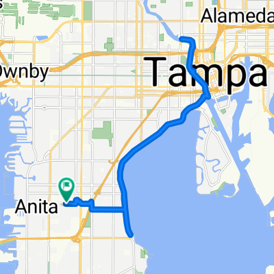
Bike to Work!
A cycling route starting in Tampa, Florida, United States.
Overview
About this route
- 24 min
- Duration
- 5.2 km
- Distance
- 90 m
- Ascent
- 85 m
- Descent
- 12.8 km/h
- Avg. speed
- ---
- Max. altitude

Continue with Bikemap
Use, edit, or download this cycling route
You would like to ride Bike to Work! or customize it for your own trip? Here is what you can do with this Bikemap route:
Free features
- Save this route as favorite or in collections
- Copy & plan your own version of this route
- Sync your route with Garmin or Wahoo
Premium features
Free trial for 3 days, or one-time payment. More about Bikemap Premium.
- Navigate this route on iOS & Android
- Export a GPX / KML file of this route
- Create your custom printout (try it for free)
- Download this route for offline navigation
Discover more Premium features.
Get Bikemap PremiumFrom our community
Other popular routes starting in Tampa
 Bayshore and riverwalk
- Distance
- 23.9 km
- Ascent
- 339 m
- Descent
- 324 m
- Location
- Tampa, Florida, United States
 Home, around Harbor Island and Hookers Point, around McKay Bay and home 27.4
- Distance
- 44.1 km
- Ascent
- 89 m
- Descent
- 87 m
- Location
- Tampa, Florida, United States
 November 2020 Bike Tour
- Distance
- 7.2 km
- Ascent
- 115 m
- Descent
- 124 m
- Location
- Tampa, Florida, United States
 West Bay View Avenue 4201, Tampa to Bayshore Boulevard 3301, Tampa
- Distance
- 20 km
- Ascent
- 21 m
- Descent
- 61 m
- Location
- Tampa, Florida, United States
 Arbor Lake Ln, Tampa to Arbor Lake Ln, Tampa
- Distance
- 6.4 km
- Ascent
- 99 m
- Descent
- 98 m
- Location
- Tampa, Florida, United States
 4 Aug
4 Aug- Distance
- 25.1 km
- Ascent
- 609 m
- Descent
- 605 m
- Location
- Tampa, Florida, United States
 West Bay View Avenue to West Bay View Avenue
- Distance
- 26.3 km
- Ascent
- 102 m
- Descent
- 74 m
- Location
- Tampa, Florida, United States
 Ride around Downtown and Davis Island
- Distance
- 15.7 km
- Ascent
- 87 m
- Descent
- 86 m
- Location
- Tampa, Florida, United States
Open it in the app