

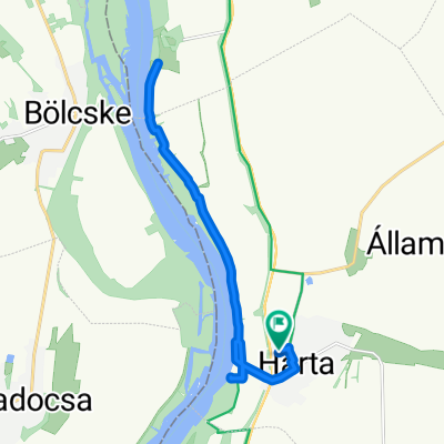
2016 09 09 Harta 33 km
A cycling route starting in Harta, Bács-Kiskun county, Hungary.
Overview
About this route
- -:--
- Duration
- 32 km
- Distance
- 13 m
- Ascent
- 15 m
- Descent
- ---
- Avg. speed
- ---
- Max. altitude

Route quality
Waytypes & surfaces along the route
Waytypes
Track
12.2 km
(38 %)
Road
7.4 km
(23 %)
Surfaces
Paved
9.6 km
(30 %)
Unpaved
0.3 km
(1 %)
Asphalt
9.6 km
(30 %)
Gravel
0.3 km
(1 %)
Undefined
22.1 km
(69 %)
Route highlights
Points of interest along the route

Photo after 7.1 km

Point of interest after 17.9 km

Point of interest after 20.3 km
Continue with Bikemap
Use, edit, or download this cycling route
You would like to ride 2016 09 09 Harta 33 km or customize it for your own trip? Here is what you can do with this Bikemap route:
Free features
- Save this route as favorite or in collections
- Copy & plan your own version of this route
- Sync your route with Garmin or Wahoo
Premium features
Free trial for 3 days, or one-time payment. More about Bikemap Premium.
- Navigate this route on iOS & Android
- Export a GPX / KML file of this route
- Create your custom printout (try it for free)
- Download this route for offline navigation
Discover more Premium features.
Get Bikemap PremiumFrom our community
Other popular routes starting in Harta
 2016 09 09 Harta 33 km
- Distance
- 32 km
- Ascent
- 13 m
- Descent
- 15 m
- Location
- Harta, Bács-Kiskun county, Hungary
 Harta - Ráckeve
- Distance
- 66.6 km
- Ascent
- 2,236 m
- Descent
- 2,231 m
- Location
- Harta, Bács-Kiskun county, Hungary
 Eurovelo 6 - 7. nap
- Distance
- 64.7 km
- Ascent
- 35 m
- Descent
- 43 m
- Location
- Harta, Bács-Kiskun county, Hungary
 Harta-Kalocsa- Szekszárd-Pécsvárad
- Distance
- 116.7 km
- Ascent
- 370 m
- Descent
- 234 m
- Location
- Harta, Bács-Kiskun county, Hungary
 Harta-Pécsvárad
- Distance
- 105.8 km
- Ascent
- 316 m
- Descent
- 205 m
- Location
- Harta, Bács-Kiskun county, Hungary
 Dózsa György utca, Harta - Dózsa György utca, Harta
- Distance
- 18.8 km
- Ascent
- 72 m
- Descent
- 71 m
- Location
- Harta, Bács-Kiskun county, Hungary
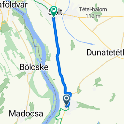 Dózsa György utca, Harta - Mester utca, Solt
- Distance
- 12.4 km
- Ascent
- 6 m
- Descent
- 4 m
- Location
- Harta, Bács-Kiskun county, Hungary
 1.10
1.10- Distance
- 72.5 km
- Ascent
- 92 m
- Descent
- 29 m
- Location
- Harta, Bács-Kiskun county, Hungary
Open it in the app