

Grenoble--Eybens--Brié--Uriage-les-Bains--Venon--Gre
A cycling route starting in Grenoble, Auvergne-Rhône-Alpes, France.
Overview
About this route
Attention, the end is a bit more complicated, but next to the tram stop 'Plaine des Sports' there is a bike lane suitable for city bikes and mountain bikes, somewhat less so for racing bikes.
- -:--
- Duration
- 30.8 km
- Distance
- 603 m
- Ascent
- 604 m
- Descent
- ---
- Avg. speed
- ---
- Max. altitude

Continue with Bikemap
Use, edit, or download this cycling route
You would like to ride Grenoble--Eybens--Brié--Uriage-les-Bains--Venon--Gre or customize it for your own trip? Here is what you can do with this Bikemap route:
Free features
- Save this route as favorite or in collections
- Copy & plan your own version of this route
- Sync your route with Garmin or Wahoo
Premium features
Free trial for 3 days, or one-time payment. More about Bikemap Premium.
- Navigate this route on iOS & Android
- Export a GPX / KML file of this route
- Create your custom printout (try it for free)
- Download this route for offline navigation
Discover more Premium features.
Get Bikemap PremiumFrom our community
Other popular routes starting in Grenoble
 Quick bike tour through Le Pont-de-Claix
- Distance
- 6.5 km
- Ascent
- 22 m
- Descent
- 0 m
- Location
- Grenoble, Auvergne-Rhône-Alpes, France
 De Rue du Berry à Rue du Berry
- Distance
- 25.7 km
- Ascent
- 734 m
- Descent
- 734 m
- Location
- Grenoble, Auvergne-Rhône-Alpes, France
 alpes 2018
- Distance
- 303.2 km
- Ascent
- 2,053 m
- Descent
- 2,232 m
- Location
- Grenoble, Auvergne-Rhône-Alpes, France
 Chartreuse - Col de Porte et col du Coq
- Distance
- 70.2 km
- Ascent
- 1,813 m
- Descent
- 1,814 m
- Location
- Grenoble, Auvergne-Rhône-Alpes, France
 Lac De Laffrey
- Distance
- 79.4 km
- Ascent
- 1,119 m
- Descent
- 1,119 m
- Location
- Grenoble, Auvergne-Rhône-Alpes, France
 Day 3 - Grenoble to Saint-Pierre-d'Argençon
- Distance
- 99.6 km
- Ascent
- 1,451 m
- Descent
- 883 m
- Location
- Grenoble, Auvergne-Rhône-Alpes, France
 5 March 23, Saint Laurent (with Ste)
- Distance
- 7.4 km
- Ascent
- 40 m
- Descent
- 42 m
- Location
- Grenoble, Auvergne-Rhône-Alpes, France
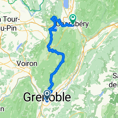 Grenoble - Chambéry
- Distance
- 104.5 km
- Ascent
- 2,217 m
- Descent
- 2,143 m
- Location
- Grenoble, Auvergne-Rhône-Alpes, France
Open it in the app