

Overview
About this route
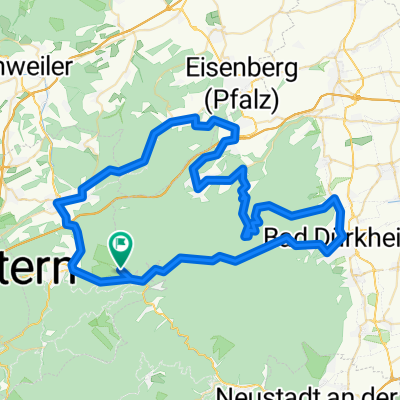
Start: Trippstadt Waypoints: Johanniskreuz, Elmsteiner Tal Destination & overnight: Landau (Pfalz) or Nussdorf
- -:--
- Duration
- 74.9 km
- Distance
- 949 m
- Ascent
- 1,027 m
- Descent
- ---
- Avg. speed
- ---
- Max. altitude

Part of
2018 Pfalz
4 stages
Route quality
Waytypes & surfaces along the route
Waytypes
Road
14.2 km
(19 %)
Track
13.5 km
(18 %)
Surfaces
Paved
57.7 km
(77 %)
Unpaved
8.2 km
(11 %)
Asphalt
54.7 km
(73 %)
Unpaved (undefined)
4.5 km
(6 %)
Continue with Bikemap
Use, edit, or download this cycling route
You would like to ride Pfalz T3 or customize it for your own trip? Here is what you can do with this Bikemap route:
Free features
- Save this route as favorite or in collections
- Copy & plan your own version of this route
- Sync your route with Garmin or Wahoo
Premium features
Free trial for 3 days, or one-time payment. More about Bikemap Premium.
- Navigate this route on iOS & Android
- Export a GPX / KML file of this route
- Create your custom printout (try it for free)
- Download this route for offline navigation
Discover more Premium features.
Get Bikemap PremiumFrom our community
Other popular routes starting in Frankenstein
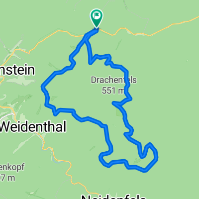 Isenachweiher-Lambertskreuz-Drachenfels
- Distance
- 22.4 km
- Ascent
- 592 m
- Descent
- 592 m
- Location
- Frankenstein, Rhineland-Palatinate, Germany
 1Bordmühle-WLeiningen-Schwarzsohl-Z31-440
- Distance
- 30.5 km
- Ascent
- 508 m
- Descent
- 508 m
- Location
- Frankenstein, Rhineland-Palatinate, Germany
 über Lindemannsruhe
- Distance
- 75.1 km
- Ascent
- 1,645 m
- Descent
- 1,661 m
- Location
- Frankenstein, Rhineland-Palatinate, Germany
 Frankenstein - KL Gartenschau - Frankenstein
- Distance
- 44.1 km
- Ascent
- 558 m
- Descent
- 558 m
- Location
- Frankenstein, Rhineland-Palatinate, Germany
 Frankensteiner Stich
- Distance
- 2.6 km
- Ascent
- 130 m
- Descent
- 9 m
- Location
- Frankenstein, Rhineland-Palatinate, Germany
 Moderate route in Kaiserslautern
- Distance
- 19.7 km
- Ascent
- 176 m
- Descent
- 140 m
- Location
- Frankenstein, Rhineland-Palatinate, Germany
 Pfalz T3
- Distance
- 74.9 km
- Ascent
- 949 m
- Descent
- 1,027 m
- Location
- Frankenstein, Rhineland-Palatinate, Germany
 Frankenstein-Weidenthal-SiS
- Distance
- 5.1 km
- Ascent
- 169 m
- Descent
- 104 m
- Location
- Frankenstein, Rhineland-Palatinate, Germany
Open it in the app