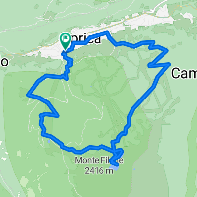
Stage 3: Aprica- Tolmezzo
A cycling route starting in Aprica, Lombardy, Italy.
Overview
About this route
- -:--
- Duration
- 448.7 km
- Distance
- 8,527 m
- Ascent
- 9,377 m
- Descent
- ---
- Avg. speed
- ---
- Max. altitude
Route quality
Waytypes & surfaces along the route
Waytypes
Quiet road
76.3 km
(17 %)
Track
44.9 km
(10 %)
Surfaces
Paved
305.1 km
(68 %)
Unpaved
44.9 km
(10 %)
Asphalt
300.6 km
(67 %)
Gravel
26.9 km
(6 %)
Route highlights
Points of interest along the route
Point of interest after 53 km
Passo di Gavia (2652m)
Point of interest after 95.4 km
Passo dello Stelvio (2757m)
Point of interest after 284.1 km
Passo Pordoi (2239m)
Point of interest after 325 km
Passo di Giau (2236m)
Continue with Bikemap
Use, edit, or download this cycling route
You would like to ride Stage 3: Aprica- Tolmezzo or customize it for your own trip? Here is what you can do with this Bikemap route:
Free features
- Save this route as favorite or in collections
- Copy & plan your own version of this route
- Split it into stages to create a multi-day tour
- Sync your route with Garmin or Wahoo
Premium features
Free trial for 3 days, or one-time payment. More about Bikemap Premium.
- Navigate this route on iOS & Android
- Export a GPX / KML file of this route
- Create your custom printout (try it for free)
- Download this route for offline navigation
Discover more Premium features.
Get Bikemap PremiumFrom our community
Other popular routes starting in Aprica
- aprica lago palabione
- Distance
- 14 km
- Ascent
- 989 m
- Descent
- 989 m
- Location
- Aprica, Lombardy, Italy
- Strade del Giro d'Italia
- Distance
- 39 km
- Ascent
- 1,287 m
- Descent
- 1,286 m
- Location
- Aprica, Lombardy, Italy
- APRICA GAVIA APRICA
- Distance
- 73.9 km
- Ascent
- 1,770 m
- Descent
- 1,770 m
- Location
- Aprica, Lombardy, Italy
- Giro 2011 - Etapp 3
- Distance
- 83.9 km
- Ascent
- 95 m
- Descent
- 1,068 m
- Location
- Aprica, Lombardy, Italy
- camping aprica rifugio magnolta
- Distance
- 9.5 km
- Ascent
- 943 m
- Descent
- 122 m
- Location
- Aprica, Lombardy, Italy
- APRICA - GAVIA - APRICA
- Distance
- 154.1 km
- Ascent
- 3,334 m
- Descent
- 3,332 m
- Location
- Aprica, Lombardy, Italy
- Stage 3: Aprica- Tolmezzo
- Distance
- 448.7 km
- Ascent
- 8,527 m
- Descent
- 9,377 m
- Location
- Aprica, Lombardy, Italy
- Giro dei Terrazzamenti
- Distance
- 44.2 km
- Ascent
- 1,444 m
- Descent
- 1,443 m
- Location
- Aprica, Lombardy, Italy
Open it in the app