

Gyula-Tata
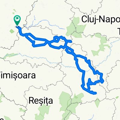
A cycling route starting in Gyula, Bekes County, Hungary.
Overview
About this route
Gyula -Tata / UCH team
- -:--
- Duration
- 365.1 km
- Distance
- 416 m
- Ascent
- 366 m
- Descent
- ---
- Avg. speed
- ---
- Max. altitude

Route quality
Waytypes & surfaces along the route
Waytypes
Cycleway
142.4 km
(39 %)
Quiet road
43.8 km
(12 %)
Surfaces
Paved
241 km
(66 %)
Asphalt
222.7 km
(61 %)
Paved (undefined)
18.3 km
(5 %)
Undefined
124.1 km
(34 %)
Route highlights
Points of interest along the route
Point of interest after 0 km
INDULÁSI PONT Dreher Presszó Zrínyi utca 1 5700 Gyula TIME:17:00
Point of interest after 29.7 km
Csekpoint1 Békéscsaba MOL Benzikút Szegedi út. nyitva: 0-24
Point of interest after 124.5 km
2. csekpoint Szeged Dorozsmai út 1. ÖMV benzinkút Nyitva: 0-24
Point of interest after 208.7 km
3.csekpoint Kiskőrös Dózsa György út 99 ÖMV benzinkút Nyitva: 0-24
Point of interest after 333.3 km
4. csekpoint Csákvár, kálvária ut 1. Kálvária pizzéria 0-24 nyitva
Point of interest after 365.1 km
2890 Tata, Fáklya u. 4. RECEPCIÓ
Continue with Bikemap
Use, edit, or download this cycling route
You would like to ride Gyula-Tata or customize it for your own trip? Here is what you can do with this Bikemap route:
Free features
- Save this route as favorite or in collections
- Copy & plan your own version of this route
- Split it into stages to create a multi-day tour
- Sync your route with Garmin or Wahoo
Premium features
Free trial for 3 days, or one-time payment. More about Bikemap Premium.
- Navigate this route on iOS & Android
- Export a GPX / KML file of this route
- Create your custom printout (try it for free)
- Download this route for offline navigation
Discover more Premium features.
Get Bikemap PremiumFrom our community
Other popular routes starting in Gyula
 Erdélyi-érchegyseg, Kudzsiri-havasok, Muntii Metaliferi, Muntii Sureanu
- Distance
- 809.9 km
- Ascent
- 14,016 m
- Descent
- 14,015 m
- Location
- Gyula, Bekes County, Hungary
 to work
- Distance
- 3.3 km
- Ascent
- 8 m
- Descent
- 9 m
- Location
- Gyula, Bekes County, Hungary
 Gyula-Tata
- Distance
- 365.1 km
- Ascent
- 416 m
- Descent
- 366 m
- Location
- Gyula, Bekes County, Hungary
 Erdélyi középhegység/Apuseni mountain
- Distance
- 726.9 km
- Ascent
- 10,485 m
- Descent
- 10,484 m
- Location
- Gyula, Bekes County, Hungary
 008 - Gyula belváros 4km-es
- Distance
- 3.8 km
- Ascent
- 8 m
- Descent
- 8 m
- Location
- Gyula, Bekes County, Hungary
 Lengthy bike tour through Gyula
- Distance
- 42.8 km
- Ascent
- 30 m
- Descent
- 33 m
- Location
- Gyula, Bekes County, Hungary
 A határon mindkét oldalán
- Distance
- 122.7 km
- Ascent
- 18 m
- Descent
- 20 m
- Location
- Gyula, Bekes County, Hungary
 Fekete Körörs gát-túra
- Distance
- 46.3 km
- Ascent
- 51 m
- Descent
- 51 m
- Location
- Gyula, Bekes County, Hungary
Open it in the app