

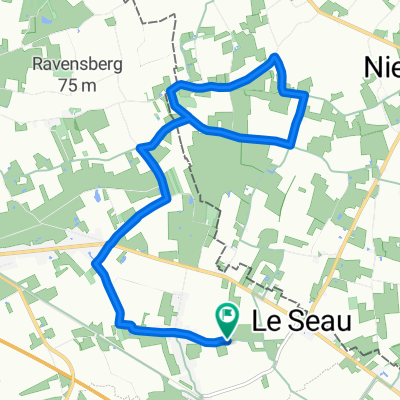
Sortie de 42.5 km (Mont Noir, Vert Mont, Mont des cats)
A cycling route starting in Steenwerck, Hauts-de-France, France.
Overview
About this route
Sortie de 42.5 km (Mont Noir, Vert Mont, Mont des cats)
- -:--
- Duration
- 42.5 km
- Distance
- 325 m
- Ascent
- 325 m
- Descent
- ---
- Avg. speed
- ---
- Max. altitude

Route quality
Waytypes & surfaces along the route
Waytypes
Quiet road
21.5 km
(50 %)
Road
16.2 km
(38 %)
Surfaces
Paved
37.3 km
(88 %)
Asphalt
37.3 km
(88 %)
Undefined
5.3 km
(12 %)
Continue with Bikemap
Use, edit, or download this cycling route
You would like to ride Sortie de 42.5 km (Mont Noir, Vert Mont, Mont des cats) or customize it for your own trip? Here is what you can do with this Bikemap route:
Free features
- Save this route as favorite or in collections
- Copy & plan your own version of this route
- Sync your route with Garmin or Wahoo
Premium features
Free trial for 3 days, or one-time payment. More about Bikemap Premium.
- Navigate this route on iOS & Android
- Export a GPX / KML file of this route
- Create your custom printout (try it for free)
- Download this route for offline navigation
Discover more Premium features.
Get Bikemap PremiumFrom our community
Other popular routes starting in Steenwerck
 Sortie de 42.5 km (Mont Noir, Vert Mont, Mont des cats)
- Distance
- 42.5 km
- Ascent
- 325 m
- Descent
- 325 m
- Location
- Steenwerck, Hauts-de-France, France
 Supersonic route in Méteren
- Distance
- 12.2 km
- Ascent
- 67 m
- Descent
- 57 m
- Location
- Steenwerck, Hauts-de-France, France
 Rue de l'Église de la Creche, Bailleul à Rue de l'Église de la Creche, Bailleul
- Distance
- 13.5 km
- Ascent
- 88 m
- Descent
- 92 m
- Location
- Steenwerck, Hauts-de-France, France
 1124–1170 Chemin de Halage, Bailleul à 2 Rue Jean Monnet, Armentières
- Distance
- 9.2 km
- Ascent
- 6 m
- Descent
- 11 m
- Location
- Steenwerck, Hauts-de-France, France
 Cracking ride in Lille
- Distance
- 25.6 km
- Ascent
- 140 m
- Descent
- 134 m
- Location
- Steenwerck, Hauts-de-France, France
Open it in the app