

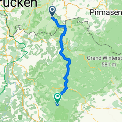
10. Hornbach - Vinningen - Wissembourg
A cycling route starting in Hornbach, Rhineland-Palatinate, Germany.
Overview
About this route
10 Stage
- -:--
- Duration
- 72.4 km
- Distance
- 551 m
- Ascent
- 632 m
- Descent
- ---
- Avg. speed
- ---
- Max. altitude
Route quality
Waytypes & surfaces along the route
Waytypes
Track
28.9 km
(40 %)
Cycleway
5.1 km
(7 %)
Surfaces
Paved
61.5 km
(85 %)
Unpaved
5.1 km
(7 %)
Asphalt
53.5 km
(74 %)
Paved (undefined)
8 km
(11 %)
Route highlights
Points of interest along the route
Accommodation after 0 km
Gästehaus Gebauer, Butterweg 4, Hornbach, 66500
Point of interest after 68 km
Notre-Dame de Weiler-katedrala
Point of interest after 71.4 km
St. Peter in Pavla ( francosko : Église Saints-Pierre-et-Paul ) od Wissembourgu- druga največja gotska cerkev Alzaciji po katedrale v Strasbourgu .
Point of interest after 71.4 km
Wissembourg-Salt House-2 A rue du Marche aux Poissons, 67160 Wissembourg Lahko ga prepoznamo po svoji strehi, razdeljenem na nadstreški v nadstropjih, ki se odpirajo na balkone. Na začetku je bila bolnišnica (1448), kasneje pa skladišče soli in klavnica.
Point of interest after 71.6 km
Office de Tourisme de Wissembourg-11 Place de la Republique, 67163 Wissembourg, France
Accommodation after 72.3 km
nočitev 10- Citotel Hôtel d'Alsace , 16 rue Vauban, Wissembourg, 67160, Francija
Continue with Bikemap
Use, edit, or download this cycling route
You would like to ride 10. Hornbach - Vinningen - Wissembourg or customize it for your own trip? Here is what you can do with this Bikemap route:
Free features
- Save this route as favorite or in collections
- Copy & plan your own version of this route
- Sync your route with Garmin or Wahoo
Premium features
Free trial for 3 days, or one-time payment. More about Bikemap Premium.
- Navigate this route on iOS & Android
- Export a GPX / KML file of this route
- Create your custom printout (try it for free)
- Download this route for offline navigation
Discover more Premium features.
Get Bikemap PremiumFrom our community
Other popular routes starting in Hornbach
 25-09-06 route du moulin
- Distance
- 46.7 km
- Ascent
- 309 m
- Descent
- 349 m
- Location
- Hornbach, Rhineland-Palatinate, Germany
 DT, Trails und Hügel
- Distance
- 42.9 km
- Ascent
- 680 m
- Descent
- 677 m
- Location
- Hornbach, Rhineland-Palatinate, Germany
 Lazy Sunday Afternoon
- Distance
- 47.6 km
- Ascent
- 554 m
- Descent
- 554 m
- Location
- Hornbach, Rhineland-Palatinate, Germany
 Feierabend Runde
- Distance
- 47.9 km
- Ascent
- 522 m
- Descent
- 567 m
- Location
- Hornbach, Rhineland-Palatinate, Germany
 Col de Wengelsbach und zurück
- Distance
- 65.5 km
- Ascent
- 631 m
- Descent
- 536 m
- Location
- Hornbach, Rhineland-Palatinate, Germany
 Europäischer Mühlenradweg
- Distance
- 47.7 km
- Ascent
- 305 m
- Descent
- 306 m
- Location
- Hornbach, Rhineland-Palatinate, Germany
 Zum Cafe nach La Petite Pierre und Retour
- Distance
- 52.3 km
- Ascent
- 500 m
- Descent
- 459 m
- Location
- Hornbach, Rhineland-Palatinate, Germany
 Teil des Europäischen Mühlenradweges
- Distance
- 32.8 km
- Ascent
- 336 m
- Descent
- 339 m
- Location
- Hornbach, Rhineland-Palatinate, Germany
Open it in the app