
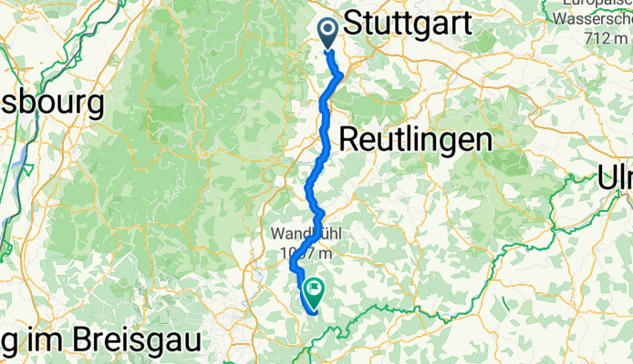
Dä-Mahlstetten
A cycling route starting in Ostelsheim, Baden-Württemberg, Germany.
Overview
About this route
- -:--
- Duration
- 93.3 km
- Distance
- 907 m
- Ascent
- 454 m
- Descent
- ---
- Avg. speed
- ---
- Max. altitude

Route quality
Waytypes & surfaces along the route
Waytypes
Road
33.4 km
(36 %)
Track
18.4 km
(20 %)
Surfaces
Paved
71.9 km
(77 %)
Unpaved
3.2 km
(3 %)
Asphalt
64.9 km
(70 %)
Paved (undefined)
6.5 km
(7 %)
Continue with Bikemap
Use, edit, or download this cycling route
You would like to ride Dä-Mahlstetten or customize it for your own trip? Here is what you can do with this Bikemap route:
Free features
- Save this route as favorite or in collections
- Copy & plan your own version of this route
- Split it into stages to create a multi-day tour
- Sync your route with Garmin or Wahoo
Premium features
Free trial for 3 days, or one-time payment. More about Bikemap Premium.
- Navigate this route on iOS & Android
- Export a GPX / KML file of this route
- Create your custom printout (try it for free)
- Download this route for offline navigation
Discover more Premium features.
Get Bikemap PremiumFrom our community
Other popular routes starting in Ostelsheim
 Hübner Osteopath
- Distance
- 17.2 km
- Ascent
- 178 m
- Descent
- 226 m
- Location
- Ostelsheim, Baden-Württemberg, Germany
 Pforzheim über Calmbach
- Distance
- 77.4 km
- Ascent
- 815 m
- Descent
- 816 m
- Location
- Ostelsheim, Baden-Württemberg, Germany
 Pforzheim über Hohenwart
- Distance
- 76.1 km
- Ascent
- 535 m
- Descent
- 535 m
- Location
- Ostelsheim, Baden-Württemberg, Germany
 Dä-Mahlstetten
- Distance
- 93.3 km
- Ascent
- 907 m
- Descent
- 454 m
- Location
- Ostelsheim, Baden-Württemberg, Germany
 HK Dätzingen Runde
- Distance
- 6.4 km
- Ascent
- 139 m
- Descent
- 140 m
- Location
- Ostelsheim, Baden-Württemberg, Germany
 20150808_172925.gpx
- Distance
- 34.3 km
- Ascent
- 333 m
- Descent
- 361 m
- Location
- Ostelsheim, Baden-Württemberg, Germany
 2018.10.06 Pforzheim rund
- Distance
- 73.8 km
- Ascent
- 1,213 m
- Descent
- 1,266 m
- Location
- Ostelsheim, Baden-Württemberg, Germany
 Dä-Würzbach-Calmbach-PF
- Distance
- 100 km
- Ascent
- 1,973 m
- Descent
- 1,972 m
- Location
- Ostelsheim, Baden-Württemberg, Germany
Open it in the app