

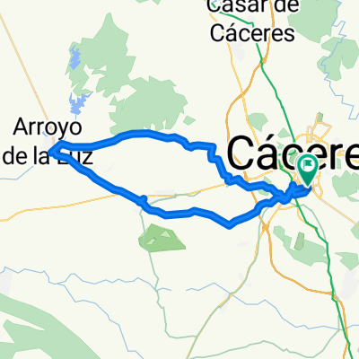
Ruta de las Avutardas
A cycling route starting in Cáceres, Extremadura, Spain.
Overview
About this route
Route that runs entirely through valleys and public roads. We will cross the Sierra de La Mosca along the path of Los Hornos to Sierra de Fuentes. Then we will cross the plains and if we are lucky we might see a flock of Bustards. Be careful if the day is windy, in the plains the wind blows hard.
- -:--
- Duration
- 52.1 km
- Distance
- 476 m
- Ascent
- 476 m
- Descent
- ---
- Avg. speed
- ---
- Max. altitude

Route quality
Waytypes & surfaces along the route
Waytypes
Track
29.2 km
(56 %)
Quiet road
20.8 km
(40 %)
Surfaces
Paved
14.1 km
(27 %)
Unpaved
35.9 km
(69 %)
Ground
17.2 km
(33 %)
Gravel
14.6 km
(28 %)
Route highlights
Points of interest along the route
Point of interest after 21.9 km
Bonitas vistas
Continue with Bikemap
Use, edit, or download this cycling route
You would like to ride Ruta de las Avutardas or customize it for your own trip? Here is what you can do with this Bikemap route:
Free features
- Save this route as favorite or in collections
- Copy & plan your own version of this route
- Sync your route with Garmin or Wahoo
Premium features
Free trial for 3 days, or one-time payment. More about Bikemap Premium.
- Navigate this route on iOS & Android
- Export a GPX / KML file of this route
- Create your custom printout (try it for free)
- Download this route for offline navigation
Discover more Premium features.
Get Bikemap PremiumFrom our community
Other popular routes starting in Cáceres
 Ruta de las Avutardas
- Distance
- 52.1 km
- Ascent
- 476 m
- Descent
- 476 m
- Location
- Cáceres, Extremadura, Spain
 CASAR- RIBEROS MONROY
- Distance
- 73.6 km
- Ascent
- 543 m
- Descent
- 538 m
- Location
- Cáceres, Extremadura, Spain
 Cáceres - Ermita de San Jorge
- Distance
- 38.3 km
- Ascent
- 360 m
- Descent
- 337 m
- Location
- Cáceres, Extremadura, Spain
 Tubos puente almonte
- Distance
- 18.3 km
- Ascent
- 100 m
- Descent
- 217 m
- Location
- Cáceres, Extremadura, Spain
 CC - Barruecos - Cefot - CC
- Distance
- 38.9 km
- Ascent
- 204 m
- Descent
- 230 m
- Location
- Cáceres, Extremadura, Spain
 Perderse
- Distance
- 35.8 km
- Ascent
- 674 m
- Descent
- 703 m
- Location
- Cáceres, Extremadura, Spain
 RUTA 7- CC-ARENALES-ARROYO
- Distance
- 44.9 km
- Ascent
- 169 m
- Descent
- 176 m
- Location
- Cáceres, Extremadura, Spain
 CACERES - BADAJOZ (LLA) ETAPA 2
- Distance
- 209.8 km
- Ascent
- 892 m
- Descent
- 1,093 m
- Location
- Cáceres, Extremadura, Spain
Open it in the app