

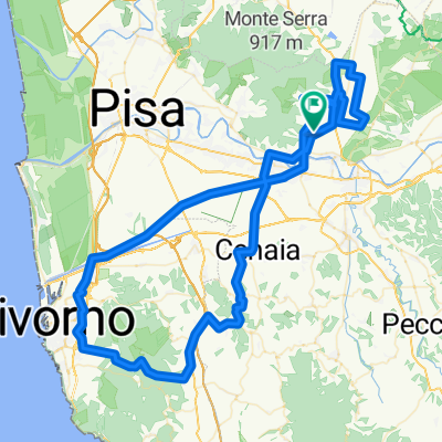
serra mtb fino all'antenne
A cycling route starting in Vicopisano, Tuscany, Italy.
Overview
About this route
S.iacopo, campi solari-serra di sotto, piazzale-cristalli,lombardona-il silvio, molino.
- -:--
- Duration
- 32.2 km
- Distance
- 1,157 m
- Ascent
- 1,157 m
- Descent
- ---
- Avg. speed
- ---
- Avg. speed

Route quality
Waytypes & surfaces along the route
Waytypes
Track
22.7 km
(71 %)
Path
4.7 km
(15 %)
Surfaces
Paved
4.3 km
(13 %)
Unpaved
23.5 km
(73 %)
Ground
16.2 km
(50 %)
Asphalt
3.7 km
(11 %)
Continue with Bikemap
Use, edit, or download this cycling route
You would like to ride serra mtb fino all'antenne or customize it for your own trip? Here is what you can do with this Bikemap route:
Free features
- Save this route as favorite or in collections
- Copy & plan your own version of this route
- Sync your route with Garmin or Wahoo
Premium features
Free trial for 3 days, or one-time payment. More about Bikemap Premium.
- Navigate this route on iOS & Android
- Export a GPX / KML file of this route
- Create your custom printout (try it for free)
- Download this route for offline navigation
Discover more Premium features.
Get Bikemap PremiumFrom our community
Other popular routes starting in Vicopisano
 Serra con discesa da Compito
- Distance
- 43 km
- Ascent
- 933 m
- Descent
- 930 m
- Location
- Vicopisano, Tuscany, Italy
 Vicopisano - Calcinaia - Santa Maria a Monte - Massarella - Bientina - Vicopisano
- Distance
- 58.4 km
- Ascent
- 449 m
- Descent
- 451 m
- Location
- Vicopisano, Tuscany, Italy
 MTB...i fichi-serra di sotto-colle del prato-campo di croce- poppo-sottopoppo e picabeba-montemagno-verruca-vicopisano
- Distance
- 37 km
- Ascent
- 1,361 m
- Descent
- 1,361 m
- Location
- Vicopisano, Tuscany, Italy
 Bike&Oil Vicopisano_TCI day 2
- Distance
- 17.2 km
- Ascent
- 221 m
- Descent
- 230 m
- Location
- Vicopisano, Tuscany, Italy
 Lange Radrunde durch Vicopisano
- Distance
- 40.4 km
- Ascent
- 430 m
- Descent
- 270 m
- Location
- Vicopisano, Tuscany, Italy
 serra mtb fino all'antenne
- Distance
- 32.2 km
- Ascent
- 1,157 m
- Descent
- 1,157 m
- Location
- Vicopisano, Tuscany, Italy
 20130511-Fauglia_ValleBenedetta_Puntone_Buti
- Distance
- 124.4 km
- Ascent
- 687 m
- Descent
- 683 m
- Location
- Vicopisano, Tuscany, Italy
 Vicopisano - Monte Serra - Icecream in Lucca - San Giuliano Terme - Vicopisano
- Distance
- 70.4 km
- Ascent
- 1,181 m
- Descent
- 1,180 m
- Location
- Vicopisano, Tuscany, Italy
Open it in the app