

GIAU 2
A cycling route starting in Selva di Cadore, Veneto, Italy.
Overview
About this route
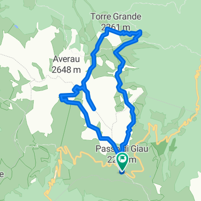
Selva di cadore , Passo Giau , Cortina dampezo , Passo Falzarego , Dagonera , Caprile , Colle de santa lucia , Selva di cadore , 78 km 2580 desnivel
- -:--
- Duration
- 78.4 km
- Distance
- 2,327 m
- Ascent
- 2,278 m
- Descent
- ---
- Avg. speed
- ---
- Max. altitude

Route quality
Waytypes & surfaces along the route
Waytypes
Busy road
66.9 km
(85 %)
Quiet road
8.2 km
(11 %)
Surfaces
Paved
69.3 km
(88 %)
Unpaved
1.5 km
(2 %)
Asphalt
68.8 km
(88 %)
Gravel
1.5 km
(2 %)
Continue with Bikemap
Use, edit, or download this cycling route
You would like to ride GIAU 2 or customize it for your own trip? Here is what you can do with this Bikemap route:
Free features
- Save this route as favorite or in collections
- Copy & plan your own version of this route
- Sync your route with Garmin or Wahoo
Premium features
Free trial for 3 days, or one-time payment. More about Bikemap Premium.
- Navigate this route on iOS & Android
- Export a GPX / KML file of this route
- Create your custom printout (try it for free)
- Download this route for offline navigation
Discover more Premium features.
Get Bikemap PremiumFrom our community
Other popular routes starting in Selva di Cadore
 Selva Di Cadore - Passo Staulanza - Passo Duran -
- Distance
- 69.7 km
- Ascent
- 1,744 m
- Descent
- 1,751 m
- Location
- Selva di Cadore, Veneto, Italy
 Sellaronda con partenza da Santa Fosca
- Distance
- 103.8 km
- Ascent
- 2,293 m
- Descent
- 2,293 m
- Location
- Selva di Cadore, Veneto, Italy
 Rifugio Città di Fiume - Malga Prendera - Forcella Ambrizzola - Mondeval
- Distance
- 16.7 km
- Ascent
- 874 m
- Descent
- 866 m
- Location
- Selva di Cadore, Veneto, Italy
 Anello Passo Giau - 5 Torri
- Distance
- 10.9 km
- Ascent
- 571 m
- Descent
- 571 m
- Location
- Selva di Cadore, Veneto, Italy
 Q 9/16 Selva di Cadore to Palmanova
- Distance
- 171 km
- Ascent
- 787 m
- Descent
- 2,191 m
- Location
- Selva di Cadore, Veneto, Italy
 MARMOLADA Y SAN PELEGRINO
- Distance
- 96.3 km
- Ascent
- 2,329 m
- Descent
- 2,311 m
- Location
- Selva di Cadore, Veneto, Italy
 Tag 4 Dolo-Runde
- Distance
- 34.4 km
- Ascent
- 817 m
- Descent
- 2,243 m
- Location
- Selva di Cadore, Veneto, Italy
 Passo Giao - Passo Falzarego - St. Martin in Gsies
- Distance
- 96.9 km
- Ascent
- 1,599 m
- Descent
- 2,541 m
- Location
- Selva di Cadore, Veneto, Italy
Open it in the app