

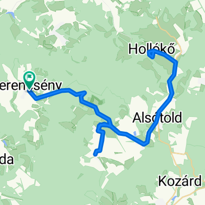
7. Hortobágy Tour: Hollókő-Aszód
A cycling route starting in Rimóc, Nógrád megye, Hungary.
Overview
About this route
- -:--
- Duration
- 52.9 km
- Distance
- 221 m
- Ascent
- 416 m
- Descent
- ---
- Avg. speed
- ---
- Max. altitude

Route quality
Waytypes & surfaces along the route
Waytypes
Quiet road
2.6 km
(5 %)
Road
2.1 km
(4 %)
Surfaces
Paved
36 km
(68 %)
Asphalt
36 km
(68 %)
Undefined
16.9 km
(32 %)
Continue with Bikemap
Use, edit, or download this cycling route
You would like to ride 7. Hortobágy Tour: Hollókő-Aszód or customize it for your own trip? Here is what you can do with this Bikemap route:
Free features
- Save this route as favorite or in collections
- Copy & plan your own version of this route
- Sync your route with Garmin or Wahoo
Premium features
Free trial for 3 days, or one-time payment. More about Bikemap Premium.
- Navigate this route on iOS & Android
- Export a GPX / KML file of this route
- Create your custom printout (try it for free)
- Download this route for offline navigation
Discover more Premium features.
Get Bikemap PremiumFrom our community
Other popular routes starting in Rimóc
 Herencsény-Galya-Kékes-Gyöngyös-Herencsény
- Distance
- 135.6 km
- Ascent
- 1,787 m
- Descent
- 1,787 m
- Location
- Rimóc, Nógrád megye, Hungary
 7. Hortobágy Tour: Hollókő-Aszód
- Distance
- 52.9 km
- Ascent
- 221 m
- Descent
- 416 m
- Location
- Rimóc, Nógrád megye, Hungary
 Herencsény-Hollókő-Bokor-Herencsény
- Distance
- 47.3 km
- Ascent
- 547 m
- Descent
- 544 m
- Location
- Rimóc, Nógrád megye, Hungary
 Cserháti túra
- Distance
- 63.4 km
- Ascent
- 640 m
- Descent
- 637 m
- Location
- Rimóc, Nógrád megye, Hungary
 Herencsény-Kétbodony-Herencsény
- Distance
- 55.5 km
- Ascent
- 326 m
- Descent
- 327 m
- Location
- Rimóc, Nógrád megye, Hungary
 Hollókő-Szécsény-Vác
- Distance
- 86.1 km
- Ascent
- 375 m
- Descent
- 591 m
- Location
- Rimóc, Nógrád megye, Hungary
 Herencsény-Szécsény-Gyarmat-Herencsény
- Distance
- 71.4 km
- Ascent
- 406 m
- Descent
- 406 m
- Location
- Rimóc, Nógrád megye, Hungary
 OKT Tavaszbúcsúztató Kék 1
- Distance
- 21.1 km
- Ascent
- 616 m
- Descent
- 483 m
- Location
- Rimóc, Nógrád megye, Hungary
Open it in the app