
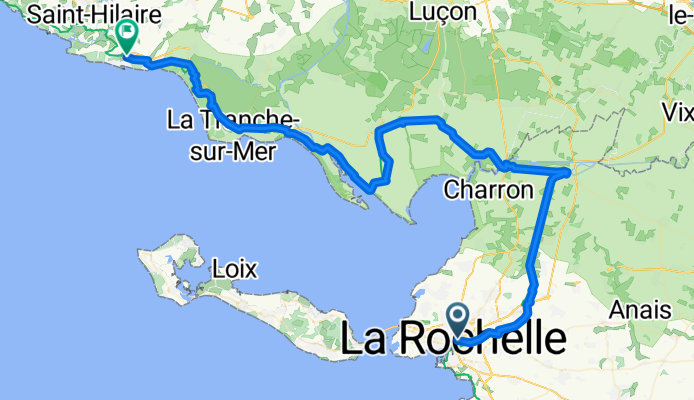
La Rochelle to Jard-sur-mer
A cycling route starting in La Rochelle, Aquitaine-Limousin-Poitou-Charentes, France.
Overview
About this route
Velodysssee stage 6. Long day 88 k+. Shortcuts may be possible on minor roads.
- -:--
- Duration
- 89 km
- Distance
- 87 m
- Ascent
- 88 m
- Descent
- ---
- Avg. speed
- ---
- Max. altitude
Route quality
Waytypes & surfaces along the route
Waytypes
Quiet road
34.4 km
(39 %)
Cycleway
23.3 km
(26 %)
Surfaces
Paved
24.9 km
(28 %)
Unpaved
21.4 km
(24 %)
Asphalt
24.4 km
(27 %)
Gravel
12.8 km
(14 %)
Continue with Bikemap
Use, edit, or download this cycling route
You would like to ride La Rochelle to Jard-sur-mer or customize it for your own trip? Here is what you can do with this Bikemap route:
Free features
- Save this route as favorite or in collections
- Copy & plan your own version of this route
- Split it into stages to create a multi-day tour
- Sync your route with Garmin or Wahoo
Premium features
Free trial for 3 days, or one-time payment. More about Bikemap Premium.
- Navigate this route on iOS & Android
- Export a GPX / KML file of this route
- Create your custom printout (try it for free)
- Download this route for offline navigation
Discover more Premium features.
Get Bikemap PremiumFrom our community
Other popular routes starting in La Rochelle
 2016J05Jour : Visite île de Ré
- Distance
- 91.3 km
- Ascent
- 60 m
- Descent
- 56 m
- Location
- La Rochelle, Aquitaine-Limousin-Poitou-Charentes, France
 Route in La Rochelle to ile de re
- Distance
- 69.7 km
- Ascent
- 126 m
- Descent
- 129 m
- Location
- La Rochelle, Aquitaine-Limousin-Poitou-Charentes, France
 La Rochelle / (les charmilles) rochefort
- Distance
- 28.4 km
- Ascent
- 60 m
- Descent
- 49 m
- Location
- La Rochelle, Aquitaine-Limousin-Poitou-Charentes, France
 La Rochelle côte nord retour Canal de Marans
- Distance
- 46.9 km
- Ascent
- 77 m
- Descent
- 79 m
- Location
- La Rochelle, Aquitaine-Limousin-Poitou-Charentes, France
 La Rochelle/Marsilly/Esnandes/côte nord
- Distance
- 34.6 km
- Ascent
- 63 m
- Descent
- 62 m
- Location
- La Rochelle, Aquitaine-Limousin-Poitou-Charentes, France
 La Rochelle to Ile de Re lighthouse return
- Distance
- 91.6 km
- Ascent
- 79 m
- Descent
- 81 m
- Location
- La Rochelle, Aquitaine-Limousin-Poitou-Charentes, France
 La Rochelle canal, inland & coast South 18 August, 14:32
- Distance
- 35.9 km
- Ascent
- 53 m
- Descent
- 53 m
- Location
- La Rochelle, Aquitaine-Limousin-Poitou-Charentes, France
 Loire Valley May 15-17
- Distance
- 468.7 km
- Ascent
- 2,467 m
- Descent
- 2,364 m
- Location
- La Rochelle, Aquitaine-Limousin-Poitou-Charentes, France
Open it in the app