

SOGp
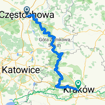
A cycling route starting in Częstochowa, Silesian Voivodeship, Poland.
Overview
About this route
planowana
- -:--
- Duration
- 157.2 km
- Distance
- 586 m
- Ascent
- 623 m
- Descent
- ---
- Avg. speed
- ---
- Max. altitude

Route quality
Waytypes & surfaces along the route
Waytypes
Quiet road
46.8 km
(30 %)
Track
40.5 km
(26 %)
Surfaces
Paved
96.3 km
(61 %)
Unpaved
39 km
(25 %)
Asphalt
95 km
(60 %)
Ground
14.8 km
(9 %)
Route highlights
Points of interest along the route
Point of interest after 20 km
OLsztyn nocleg
Point of interest after 62.9 km
planowany nocleg
Point of interest after 87.6 km
Smoleń - Nocleg
Point of interest after 131.5 km
planowany nocleg
Continue with Bikemap
Use, edit, or download this cycling route
You would like to ride SOGp or customize it for your own trip? Here is what you can do with this Bikemap route:
Free features
- Save this route as favorite or in collections
- Copy & plan your own version of this route
- Split it into stages to create a multi-day tour
- Sync your route with Garmin or Wahoo
Premium features
Free trial for 3 days, or one-time payment. More about Bikemap Premium.
- Navigate this route on iOS & Android
- Export a GPX / KML file of this route
- Create your custom printout (try it for free)
- Download this route for offline navigation
Discover more Premium features.
Get Bikemap PremiumFrom our community
Other popular routes starting in Częstochowa
 Jurajski Szlak Rowerowy Orlich Gniazd
- Distance
- 177.7 km
- Ascent
- 766 m
- Descent
- 798 m
- Location
- Częstochowa, Silesian Voivodeship, Poland
 SOGp
SOGp- Distance
- 157.2 km
- Ascent
- 586 m
- Descent
- 623 m
- Location
- Częstochowa, Silesian Voivodeship, Poland
 Szlak Orlich Gniazd
- Distance
- 184.3 km
- Ascent
- 769 m
- Descent
- 812 m
- Location
- Częstochowa, Silesian Voivodeship, Poland
 Częstochowa - Olsztyn - Słowik - Częstochowa
- Distance
- 50.4 km
- Ascent
- 176 m
- Descent
- 176 m
- Location
- Częstochowa, Silesian Voivodeship, Poland
 Murów,Srocko,Kusięta,Olsztyn,Częstochowa
- Distance
- 39.7 km
- Ascent
- 216 m
- Descent
- 209 m
- Location
- Częstochowa, Silesian Voivodeship, Poland
 Częstochowa - Blachownia Zalew - Lisiniec Pacyfik
- Distance
- 32.8 km
- Ascent
- 109 m
- Descent
- 112 m
- Location
- Częstochowa, Silesian Voivodeship, Poland
 Częstochowa - Folwark Kamyk - Częstochowa 26,2 km
- Distance
- 26.2 km
- Ascent
- 86 m
- Descent
- 86 m
- Location
- Częstochowa, Silesian Voivodeship, Poland
 Mirów
Mirów- Distance
- 39.4 km
- Ascent
- 106 m
- Descent
- 103 m
- Location
- Częstochowa, Silesian Voivodeship, Poland
Open it in the app