

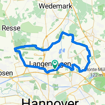
H-Leine Bordenau
A cycling route starting in Langenhagen, Lower Saxony, Germany.
Overview
About this route
- -:--
- Duration
- 65.3 km
- Distance
- 113 m
- Ascent
- 116 m
- Descent
- ---
- Avg. speed
- 67 m
- Max. altitude

Route quality
Waytypes & surfaces along the route
Waytypes
Road
25.6 km
(39 %)
Path
16.9 km
(26 %)
Surfaces
Paved
59.5 km
(91 %)
Unpaved
0.5 km
(<1 %)
Asphalt
48.2 km
(74 %)
Paving stones
7.6 km
(12 %)
Continue with Bikemap
Use, edit, or download this cycling route
You would like to ride H-Leine Bordenau or customize it for your own trip? Here is what you can do with this Bikemap route:
Free features
- Save this route as favorite or in collections
- Copy & plan your own version of this route
- Sync your route with Garmin or Wahoo
Premium features
Free trial for 3 days, or one-time payment. More about Bikemap Premium.
- Navigate this route on iOS & Android
- Export a GPX / KML file of this route
- Create your custom printout (try it for free)
- Download this route for offline navigation
Discover more Premium features.
Get Bikemap PremiumFrom our community
Other popular routes starting in Langenhagen
 RTC Altwarmbüchen 80 km CLONED FROM ROUTE 213382
- Distance
- 87.5 km
- Ascent
- 102 m
- Descent
- 101 m
- Location
- Langenhagen, Lower Saxony, Germany
 Hannover-Steinhuder Meer - Rundtour
- Distance
- 99.4 km
- Ascent
- 61 m
- Descent
- 62 m
- Location
- Langenhagen, Lower Saxony, Germany
 Langenhagen und Isernhagen Rundkurs
- Distance
- 41.7 km
- Ascent
- 81 m
- Descent
- 84 m
- Location
- Langenhagen, Lower Saxony, Germany
 20160925_Moor_geht_nicht
- Distance
- 39.9 km
- Ascent
- 134 m
- Descent
- 137 m
- Location
- Langenhagen, Lower Saxony, Germany
 15Km um den Flughafen
- Distance
- 15.3 km
- Ascent
- 34 m
- Descent
- 33 m
- Location
- Langenhagen, Lower Saxony, Germany
 Revaler Straße 16, Hannover nach Hauptstraße 3, Wunstorf
- Distance
- 18.1 km
- Ascent
- 0 m
- Descent
- 0 m
- Location
- Langenhagen, Lower Saxony, Germany
 Alt Garbsen
- Distance
- 36.1 km
- Ascent
- 27 m
- Descent
- 28 m
- Location
- Langenhagen, Lower Saxony, Germany
 Isernhagen Rundkurs
- Distance
- 27.8 km
- Ascent
- 47 m
- Descent
- 54 m
- Location
- Langenhagen, Lower Saxony, Germany
Open it in the app