Via Dolny Śląsk Sobótka Ślężański Mnich
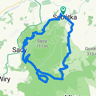
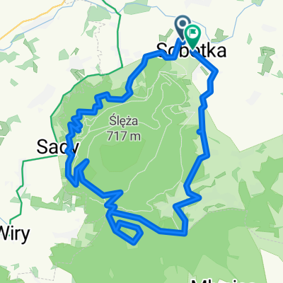
A cycling route starting in Sobótka, Lower Silesian Voivodeship, Poland.
Overview
About this route
Runda 18 km
- -:--
- Duration
- 18.1 km
- Distance
- 166 m
- Ascent
- 166 m
- Descent
- ---
- Avg. speed
- ---
- Max. altitude
Route quality
Waytypes & surfaces along the route
Waytypes
Road
13 km
(72 %)
Quiet road
4.2 km
(23 %)
Surfaces
Paved
4.2 km
(23 %)
Asphalt
4.2 km
(23 %)
Undefined
13.9 km
(77 %)
Continue with Bikemap
Use, edit, or download this cycling route
You would like to ride Via Dolny Śląsk Sobótka Ślężański Mnich or customize it for your own trip? Here is what you can do with this Bikemap route:
Free features
- Save this route as favorite or in collections
- Copy & plan your own version of this route
- Sync your route with Garmin or Wahoo
Premium features
Free trial for 3 days, or one-time payment. More about Bikemap Premium.
- Navigate this route on iOS & Android
- Export a GPX / KML file of this route
- Create your custom printout (try it for free)
- Download this route for offline navigation
Discover more Premium features.
Get Bikemap PremiumFrom our community
Other popular routes starting in Sobótka
- Propozycja trasy MTB trasy dla klientów Green eBikes
- Distance
- 33.3 km
- Ascent
- 582 m
- Descent
- 582 m
- Location
- Sobótka, Lower Silesian Voivodeship, Poland
- Pętelka wokół Ślęży czarnym szlakiem
- Distance
- 17.9 km
- Ascent
- 387 m
- Descent
- 387 m
- Location
- Sobótka, Lower Silesian Voivodeship, Poland
- chujnia po dziurach
- Distance
- 21 km
- Ascent
- 337 m
- Descent
- 337 m
- Location
- Sobótka, Lower Silesian Voivodeship, Poland
- mounting Slenza 😤
- Distance
- 12.1 km
- Ascent
- 563 m
- Descent
- 589 m
- Location
- Sobótka, Lower Silesian Voivodeship, Poland
- Przy Tamie 4, Borzygniew do Przy Tamie 4, Borzygniew
- Distance
- 18.7 km
- Ascent
- 109 m
- Descent
- 160 m
- Location
- Sobótka, Lower Silesian Voivodeship, Poland
- Dookoła Ślęży z wjazdem na szczyt
- Distance
- 27.5 km
- Ascent
- 581 m
- Descent
- 580 m
- Location
- Sobótka, Lower Silesian Voivodeship, Poland
- tapa wro
- Distance
- 46.4 km
- Ascent
- 71 m
- Descent
- 327 m
- Location
- Sobótka, Lower Silesian Voivodeship, Poland
- radunia+ślęża
- Distance
- 15.5 km
- Ascent
- 614 m
- Descent
- 614 m
- Location
- Sobótka, Lower Silesian Voivodeship, Poland
Open it in the app