

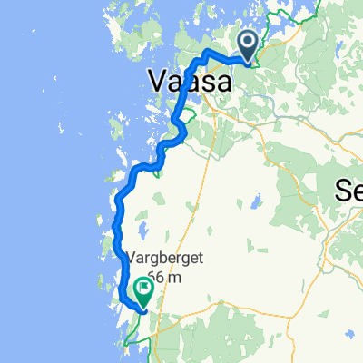
Botnia cykelrutt
A cycling route starting in Vähäykyrö, Ostrobothnia, Finland.
Overview
About this route
Botnia cycling
- -:--
- Duration
- 104.9 km
- Distance
- 0 m
- Ascent
- 0 m
- Descent
- ---
- Avg. speed
- ---
- Max. altitude

Continue with Bikemap
Use, edit, or download this cycling route
You would like to ride Botnia cykelrutt or customize it for your own trip? Here is what you can do with this Bikemap route:
Free features
- Save this route as favorite or in collections
- Copy & plan your own version of this route
- Split it into stages to create a multi-day tour
- Sync your route with Garmin or Wahoo
Premium features
Free trial for 3 days, or one-time payment. More about Bikemap Premium.
- Navigate this route on iOS & Android
- Export a GPX / KML file of this route
- Create your custom printout (try it for free)
- Download this route for offline navigation
Discover more Premium features.
Get Bikemap PremiumFrom our community
Other popular routes starting in Vähäykyrö
 TJoki- Oulu - Tjoki
- Distance
- 826.1 km
- Ascent
- 183 m
- Descent
- 183 m
- Location
- Vähäykyrö, Ostrobothnia, Finland
 Kunintie 16, Kuni à Kirkkokatu 73, Kaskinen
- Distance
- 122.4 km
- Ascent
- 253 m
- Descent
- 241 m
- Location
- Vähäykyrö, Ostrobothnia, Finland
 Botnia cykelrutt
- Distance
- 104.9 km
- Ascent
- 0 m
- Descent
- 0 m
- Location
- Vähäykyrö, Ostrobothnia, Finland
 Relaxed route in Oxkangar
- Distance
- 27.7 km
- Ascent
- 250 m
- Descent
- 236 m
- Location
- Vähäykyrö, Ostrobothnia, Finland
 Vassor - Vörå
- Distance
- 43.8 km
- Ascent
- 78 m
- Descent
- 79 m
- Location
- Vähäykyrö, Ostrobothnia, Finland
 Kunintie 19, Kuni à Pitkäkatu 44, Vaasa
- Distance
- 22.7 km
- Ascent
- 333 m
- Descent
- 319 m
- Location
- Vähäykyrö, Ostrobothnia, Finland
 1.32.2.Kuni - Närpes
- Distance
- 125.2 km
- Ascent
- 123 m
- Descent
- 126 m
- Location
- Vähäykyrö, Ostrobothnia, Finland
Open it in the app