

Possible Metro 10 route culvert road version 1
A cycling route starting in Albion, New York, United States.
Overview
About this route
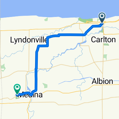
this route travels along the canal path (on roads) goes under the canal on culvert road, crosses over canal bridges (maybe too many times?!), through main street albion, start and finish at bullard
- -:--
- Duration
- 41.4 km
- Distance
- 122 m
- Ascent
- 121 m
- Descent
- ---
- Avg. speed
- ---
- Max. altitude
Route quality
Waytypes & surfaces along the route
Waytypes
Quiet road
24.8 km
(60 %)
Road
11.2 km
(27 %)
Surfaces
Paved
3.3 km
(8 %)
Unpaved
0.4 km
(1 %)
Asphalt
2.5 km
(6 %)
Paved (undefined)
0.8 km
(2 %)
Continue with Bikemap
Use, edit, or download this cycling route
You would like to ride Possible Metro 10 route culvert road version 1 or customize it for your own trip? Here is what you can do with this Bikemap route:
Free features
- Save this route as favorite or in collections
- Copy & plan your own version of this route
- Sync your route with Garmin or Wahoo
Premium features
Free trial for 3 days, or one-time payment. More about Bikemap Premium.
- Navigate this route on iOS & Android
- Export a GPX / KML file of this route
- Create your custom printout (try it for free)
- Download this route for offline navigation
Discover more Premium features.
Get Bikemap PremiumFrom our community
Other popular routes starting in Albion
 Butts Rd, Albion to 38 Main St, Brockport
- Distance
- 21.2 km
- Ascent
- 98 m
- Descent
- 100 m
- Location
- Albion, New York, United States
 Metro ten bike version 2
- Distance
- 16.4 km
- Ascent
- 43 m
- Descent
- 44 m
- Location
- Albion, New York, United States
 century
- Distance
- 60.2 km
- Ascent
- 113 m
- Descent
- 112 m
- Location
- Albion, New York, United States
 Niagara- Lakeside State Park à King Waldorf's Tent Park
- Distance
- 100.8 km
- Ascent
- 167 m
- Descent
- 71 m
- Location
- Albion, New York, United States
 Route from 990 Point Breeze Rd, Kent
- Distance
- 70.4 km
- Ascent
- 46 m
- Descent
- 40 m
- Location
- Albion, New York, United States
 hshshshshhs
- Distance
- 26.3 km
- Ascent
- 94 m
- Descent
- 78 m
- Location
- Albion, New York, United States
 Route to Adams Center
- Distance
- 309 km
- Ascent
- 1,833 m
- Descent
- 1,883 m
- Location
- Albion, New York, United States
 Archbald Rd, Waterport to Telegraph Rd, Medina
- Distance
- 32.2 km
- Ascent
- 124 m
- Descent
- 57 m
- Location
- Albion, New York, United States
Open it in the app