

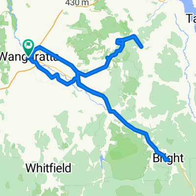
Wangaratta -Myrtleford rail trail
A cycling route starting in Wangaratta, Victoria, Australia.
Overview
About this route
- -:--
- Duration
- 56.2 km
- Distance
- 269 m
- Ascent
- 210 m
- Descent
- ---
- Avg. speed
- ---
- Max. altitude

Route quality
Waytypes & surfaces along the route
Waytypes
Cycleway
50 km
(89 %)
Quiet road
2.2 km
(4 %)
Surfaces
Paved
55 km
(98 %)
Asphalt
51.7 km
(92 %)
Paved (undefined)
3.4 km
(6 %)
Undefined
1.1 km
(2 %)
Route highlights
Points of interest along the route
Point of interest after 0 km
Wangaratta Gateway Hotel
Point of interest after 30.9 km
Everton General Store 57270255, lunch
Point of interest after 45.5 km
Highest point of section
Point of interest after 56.2 km
Golden Leaf Motor Inn
Continue with Bikemap
Use, edit, or download this cycling route
You would like to ride Wangaratta -Myrtleford rail trail or customize it for your own trip? Here is what you can do with this Bikemap route:
Free features
- Save this route as favorite or in collections
- Copy & plan your own version of this route
- Sync your route with Garmin or Wahoo
Premium features
Free trial for 3 days, or one-time payment. More about Bikemap Premium.
- Navigate this route on iOS & Android
- Export a GPX / KML file of this route
- Create your custom printout (try it for free)
- Download this route for offline navigation
Discover more Premium features.
Get Bikemap PremiumFrom our community
Other popular routes starting in Wangaratta
 Wangaratta to Albury
- Distance
- 112.9 km
- Ascent
- 1,057 m
- Descent
- 1,050 m
- Location
- Wangaratta, Victoria, Australia
 Untitled route
- Distance
- 257.3 km
- Ascent
- 1,873 m
- Descent
- 1,875 m
- Location
- Wangaratta, Victoria, Australia
 milawa loop
- Distance
- 23.5 km
- Ascent
- 22 m
- Descent
- 22 m
- Location
- Wangaratta, Victoria, Australia
 Eva Street 1, Wangaratta to Eva Street 1, Wangaratta
- Distance
- 12.8 km
- Ascent
- 14 m
- Descent
- 15 m
- Location
- Wangaratta, Victoria, Australia
 Wangaratta, Greta, Glenrowan, Wangaratta
- Distance
- 50.9 km
- Ascent
- 98 m
- Descent
- 94 m
- Location
- Wangaratta, Victoria, Australia
 Herald Sun Tour 2017 Stage 1
- Distance
- 178.9 km
- Ascent
- 2,096 m
- Descent
- 699 m
- Location
- Wangaratta, Victoria, Australia
 Wangaratta -Myrtleford rail trail
- Distance
- 56.2 km
- Ascent
- 269 m
- Descent
- 210 m
- Location
- Wangaratta, Victoria, Australia
 Wangaratta to Lilydale Bush Tour
- Distance
- 494.7 km
- Ascent
- 4,949 m
- Descent
- 4,997 m
- Location
- Wangaratta, Victoria, Australia
Open it in the app