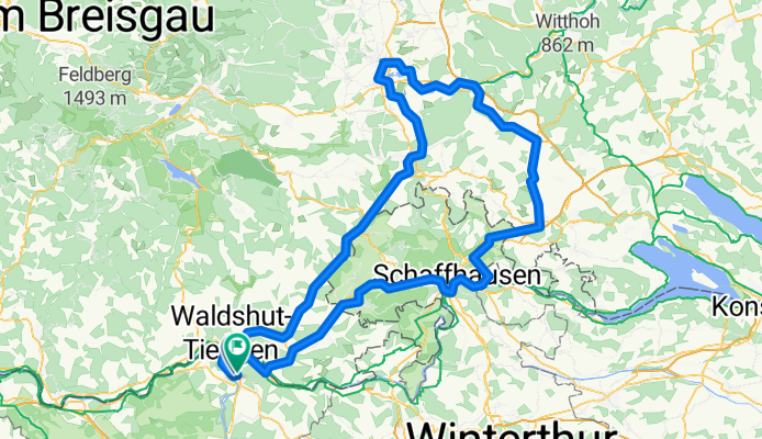
Donauesch-knapp180 aufwärts1340
A cycling route starting in Klingnau, Canton of Aargau, Switzerland.
Overview
About this route
Donauesch-knapp180 aufwärts1340, über SH nach heim.
- -:--
- Duration
- 177.9 km
- Distance
- 832 m
- Ascent
- 800 m
- Descent
- ---
- Avg. speed
- ---
- Avg. speed
Route quality
Waytypes & surfaces along the route
Waytypes
Quiet road
56.4 km
(32 %)
Track
30 km
(17 %)
Surfaces
Paved
152.3 km
(86 %)
Unpaved
10.3 km
(6 %)
Asphalt
147.8 km
(83 %)
Gravel
5.5 km
(3 %)
Continue with Bikemap
Use, edit, or download this cycling route
You would like to ride Donauesch-knapp180 aufwärts1340 or customize it for your own trip? Here is what you can do with this Bikemap route:
Free features
- Save this route as favorite or in collections
- Copy & plan your own version of this route
- Sync your route with Garmin or Wahoo
Premium features
Free trial for 3 days, or one-time payment. More about Bikemap Premium.
- Navigate this route on iOS & Android
- Export a GPX / KML file of this route
- Create your custom printout (try it for free)
- Download this route for offline navigation
Discover more Premium features.
Get Bikemap PremiumFrom our community
Other popular routes starting in Klingnau
- BG-73
- Distance
- 73.1 km
- Ascent
- 1,049 m
- Descent
- 1,052 m
- Location
- Klingnau, Canton of Aargau, Switzerland
- Klgn 68km 1200 HM
- Distance
- 68.4 km
- Ascent
- ---
- Descent
- ---
- Location
- Klingnau, Canton of Aargau, Switzerland
- Feldberg ü Schluchsee
- Distance
- 118.4 km
- Ascent
- 1,734 m
- Descent
- 1,735 m
- Location
- Klingnau, Canton of Aargau, Switzerland
- 145km Loop Around Airport
- Distance
- 150.7 km
- Ascent
- 494 m
- Descent
- 493 m
- Location
- Klingnau, Canton of Aargau, Switzerland
- nach Hohnweiler Var01
- Distance
- 222.3 km
- Ascent
- 1,232 m
- Descent
- 1,269 m
- Location
- Klingnau, Canton of Aargau, Switzerland
- HU ET-1 Heidelberg
- Distance
- 324 km
- Ascent
- 69 m
- Descent
- 318 m
- Location
- Klingnau, Canton of Aargau, Switzerland
- Schopfa-Schdaufa-Bölcha
- Distance
- 208.5 km
- Ascent
- 2,432 m
- Descent
- 2,433 m
- Location
- Klingnau, Canton of Aargau, Switzerland
- Gippingen - Ride - 9 Jun 2013
- Distance
- 53.5 km
- Ascent
- 590 m
- Descent
- 590 m
- Location
- Klingnau, Canton of Aargau, Switzerland
Open it in the app