

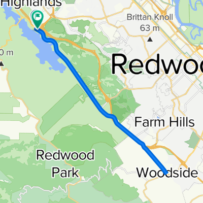
Canada-Alpine-Page Mill loop
A cycling route starting in Highlands-Baywood Park, California, United States.
Overview
About this route
- -:--
- Duration
- 93.1 km
- Distance
- 2,193 m
- Ascent
- 2,169 m
- Descent
- ---
- Avg. speed
- 746 m
- Max. altitude
Route quality
Waytypes & surfaces along the route
Waytypes
Busy road
49.3 km
(53 %)
Road
32 km
(34 %)
Surfaces
Paved
73.4 km
(79 %)
Asphalt
73.4 km
(79 %)
Undefined
19.7 km
(21 %)
Continue with Bikemap
Use, edit, or download this cycling route
You would like to ride Canada-Alpine-Page Mill loop or customize it for your own trip? Here is what you can do with this Bikemap route:
Free features
- Save this route as favorite or in collections
- Copy & plan your own version of this route
- Split it into stages to create a multi-day tour
- Sync your route with Garmin or Wahoo
Premium features
Free trial for 3 days, or one-time payment. More about Bikemap Premium.
- Navigate this route on iOS & Android
- Export a GPX / KML file of this route
- Create your custom printout (try it for free)
- Download this route for offline navigation
Discover more Premium features.
Get Bikemap PremiumFrom our community
Other popular routes starting in Highlands-Baywood Park
 Sawyer Camp Trail to Polhemus Rd
- Distance
- 28.9 km
- Ascent
- 304 m
- Descent
- 316 m
- Location
- Highlands-Baywood Park, California, United States
 Can#ada up La Honda
- Distance
- 45 km
- Ascent
- 628 m
- Descent
- 639 m
- Location
- Highlands-Baywood Park, California, United States
 28 mile ride starting at 92/Canada CLONED FROM ROUTE 421519
- Distance
- 44.8 km
- Ascent
- 507 m
- Descent
- 505 m
- Location
- Highlands-Baywood Park, California, United States
 36–40 Canada Rd, Redwood City to 2 Mount Vernon Ln, Atherton
- Distance
- 19.4 km
- Ascent
- 139 m
- Descent
- 222 m
- Location
- Highlands-Baywood Park, California, United States
 Canada Sprint
- Distance
- 9 km
- Ascent
- 134 m
- Descent
- 78 m
- Location
- Highlands-Baywood Park, California, United States
 Belmont Woods Way, Belmont to Belmont Woods Way, Belmont
- Distance
- 12.7 km
- Ascent
- 279 m
- Descent
- 274 m
- Location
- Highlands-Baywood Park, California, United States
 Skyline - Tunigas
- Distance
- 74.7 km
- Ascent
- 1,279 m
- Descent
- 1,275 m
- Location
- Highlands-Baywood Park, California, United States
 Canada to woodside
- Distance
- 23.4 km
- Ascent
- 193 m
- Descent
- 189 m
- Location
- Highlands-Baywood Park, California, United States
Open it in the app