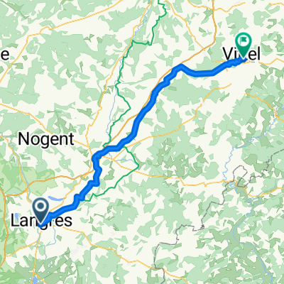
J3A REC2MIPIM 2018
A cycling route starting in Langres, Alsace-Champagne-Ardenne-Lorraine, France.
Overview
About this route
- -:--
- Duration
- 58.1 km
- Distance
- 158 m
- Ascent
- 385 m
- Descent
- ---
- Avg. speed
- ---
- Avg. speed
Route quality
Waytypes & surfaces along the route
Waytypes
Road
32.1 km
(55 %)
Busy road
21.1 km
(36 %)
Surfaces
Paved
16.2 km
(28 %)
Asphalt
15.8 km
(27 %)
Paved (undefined)
0.3 km
(<1 %)
Undefined
41.9 km
(72 %)
Continue with Bikemap
Use, edit, or download this cycling route
You would like to ride J3A REC2MIPIM 2018 or customize it for your own trip? Here is what you can do with this Bikemap route:
Free features
- Save this route as favorite or in collections
- Copy & plan your own version of this route
- Sync your route with Garmin or Wahoo
Premium features
Free trial for 3 days, or one-time payment. More about Bikemap Premium.
- Navigate this route on iOS & Android
- Export a GPX / KML file of this route
- Create your custom printout (try it for free)
- Download this route for offline navigation
Discover more Premium features.
Get Bikemap PremiumFrom our community
Other popular routes starting in Langres
- Etape 6 / St geosmes _ Vesoul
- Distance
- 82.8 km
- Ascent
- 437 m
- Descent
- 738 m
- Location
- Langres, Alsace-Champagne-Ardenne-Lorraine, France
- B 2019 E 5 var FF sud
- Distance
- 94.5 km
- Ascent
- 235 m
- Descent
- 460 m
- Location
- Langres, Alsace-Champagne-Ardenne-Lorraine, France
- Langres - Chevillard (3j)
- Distance
- 252.7 km
- Ascent
- 1,247 m
- Descent
- 896 m
- Location
- Langres, Alsace-Champagne-Ardenne-Lorraine, France
- Toul Le-Puy Etappe 3 Langres - Dijon CLONED FROM ROUTE 792483
- Distance
- 88.4 km
- Ascent
- 480 m
- Descent
- 701 m
- Location
- Langres, Alsace-Champagne-Ardenne-Lorraine, France
- J3A REC2MIPIM 2018
- Distance
- 58.1 km
- Ascent
- 158 m
- Descent
- 385 m
- Location
- Langres, Alsace-Champagne-Ardenne-Lorraine, France
- Langres-Dole
- Distance
- 128.2 km
- Ascent
- 372 m
- Descent
- 629 m
- Location
- Langres, Alsace-Champagne-Ardenne-Lorraine, France
- 2 Langres to Montelimar via Calon sur Saone, Macon, Lyon, Vienne & Valence
- Distance
- 525 km
- Ascent
- 154 m
- Descent
- 532 m
- Location
- Langres, Alsace-Champagne-Ardenne-Lorraine, France
- 11e Dag Tour de France 31-05-2022
- Distance
- 66.3 km
- Ascent
- 353 m
- Descent
- 612 m
- Location
- Langres, Alsace-Champagne-Ardenne-Lorraine, France
Open it in the app