
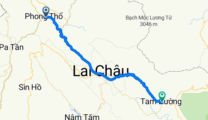
J56 - Jeudi 01 mars 2018 – Pa So (Phong Tho) – Tam Duong
A cycling route starting in Phong Thổ, Lai Châu Province, Vietnam.
Overview
About this route
J56 - Thursday, March 1, 2018 – Pa So (Phong Tho) – Tam Duong
Distance covered: 56.40 Km - Average: 11.15 Km/h
Elevation gain: 1353 m - Maximum gradient uphill: 9 %
Elevation loss: 980 m - Maximum gradient downhill: 8 %
Starting altitude: 277 m - Arrival altitude: 650 m - Maximum altitude: 1293m
- -:--
- Duration
- 57.6 km
- Distance
- 1,326 m
- Ascent
- 945 m
- Descent
- ---
- Avg. speed
- ---
- Max. altitude
Route quality
Waytypes & surfaces along the route
Waytypes
Cycleway
44.9 km
(78 %)
Road
9.2 km
(16 %)
Continue with Bikemap
Use, edit, or download this cycling route
You would like to ride J56 - Jeudi 01 mars 2018 – Pa So (Phong Tho) – Tam Duong or customize it for your own trip? Here is what you can do with this Bikemap route:
Free features
- Save this route as favorite or in collections
- Copy & plan your own version of this route
- Sync your route with Garmin or Wahoo
Premium features
Free trial for 3 days, or one-time payment. More about Bikemap Premium.
- Navigate this route on iOS & Android
- Export a GPX / KML file of this route
- Create your custom printout (try it for free)
- Download this route for offline navigation
Discover more Premium features.
Get Bikemap PremiumFrom our community
Other popular routes starting in Phong Thổ
 10 Lai Chau-Sapa
- Distance
- 66.8 km
- Ascent
- 2,853 m
- Descent
- 1,706 m
- Location
- Phong Thổ, Lai Châu Province, Vietnam
 Day 10: Phong Tho - Lai Chau
- Distance
- 31 km
- Ascent
- 938 m
- Descent
- 271 m
- Location
- Phong Thổ, Lai Châu Province, Vietnam
 Phong Tho - Lai Chau
- Distance
- 32.6 km
- Ascent
- 941 m
- Descent
- 306 m
- Location
- Phong Thổ, Lai Châu Province, Vietnam
 J56 - Jeudi 01 mars 2018 – Pa So (Phong Tho) – Tam Duong
- Distance
- 57.6 km
- Ascent
- 1,326 m
- Descent
- 945 m
- Location
- Phong Thổ, Lai Châu Province, Vietnam
Open it in the app