

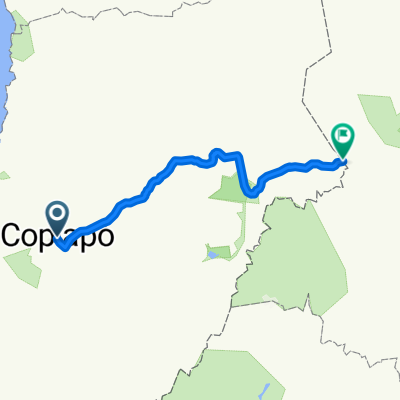
E-Bike tour por Atacama
A cycling route starting in Copiapó, Atacama, Chile.
Overview
About this route
- -:--
- Duration
- 852.2 km
- Distance
- 7,260 m
- Ascent
- 5,943 m
- Descent
- ---
- Avg. speed
- ---
- Max. altitude
Route quality
Waytypes & surfaces along the route
Waytypes
Road
102.3 km
(12 %)
Track
34.1 km
(4 %)
Surfaces
Paved
588 km
(69 %)
Unpaved
230.1 km
(27 %)
Asphalt
332.3 km
(39 %)
Paved (undefined)
255.6 km
(30 %)
Route highlights
Points of interest along the route
Accommodation after 0 km
Coral Bahia Inglesa
Accommodation after 0.1 km
Wara
Point of interest after 3.8 km
Mina Cerro Iman
Point of interest after 4.8 km
Flughafen Chamonte
Accommodation after 119 km
Inca de Oro
Accommodation after 164.4 km
Diego de Almagro
Accommodation after 220.9 km
El Salvador
Point of interest after 298.5 km
Salar de Pedernales
Accommodation after 312.6 km
La Ola
Point of interest after 321.5 km
Termas Juncal
Point of interest after 364.1 km
Salar de Maricunga
Accommodation after 435 km
Refugio Atacama - Campo Base Ojos del Salado
Accommodation after 435 km
Refugio Tejos
Accommodation after 444.1 km
Refugio Laguna Verde
Point of interest after 500.5 km
Refugio N° 5 Las Pelades
Point of interest after 556.8 km
Flughafen
Accommodation after 567.8 km
Hotel Cortaderas
Accommodation after 778.5 km
Refugio Alpino
Continue with Bikemap
Use, edit, or download this cycling route
You would like to ride E-Bike tour por Atacama or customize it for your own trip? Here is what you can do with this Bikemap route:
Free features
- Save this route as favorite or in collections
- Copy & plan your own version of this route
- Split it into stages to create a multi-day tour
- Sync your route with Garmin or Wahoo
Premium features
Free trial for 3 days, or one-time payment. More about Bikemap Premium.
- Navigate this route on iOS & Android
- Export a GPX / KML file of this route
- Create your custom printout (try it for free)
- Download this route for offline navigation
Discover more Premium features.
Get Bikemap PremiumFrom our community
Other popular routes starting in Copiapó
 Salitrera Peruana 1769, Copiapó a Salitrera Peruana 1770, Copiapó
- Distance
- 29.5 km
- Ascent
- 1,815 m
- Descent
- 1,816 m
- Location
- Copiapó, Atacama, Chile
 cerro iman
- Distance
- 18.6 km
- Ascent
- 96 m
- Descent
- 234 m
- Location
- Copiapó, Atacama, Chile
 E-Bike tour por Atacama
- Distance
- 852.2 km
- Ascent
- 7,260 m
- Descent
- 5,943 m
- Location
- Copiapó, Atacama, Chile
 Cardones - Cerro Imán
- Distance
- 49.3 km
- Ascent
- 780 m
- Descent
- 783 m
- Location
- Copiapó, Atacama, Chile
 Copiapó - Chamonate - Bypass Toledo - Copiapó
- Distance
- 44 km
- Ascent
- 186 m
- Descent
- 184 m
- Location
- Copiapó, Atacama, Chile
 Copiapo - Paso S Francisco
- Distance
- 282.3 km
- Ascent
- 5,164 m
- Descent
- 795 m
- Location
- Copiapó, Atacama, Chile
 paipote - parque Kaukari
- Distance
- 15.2 km
- Ascent
- 181 m
- Descent
- 183 m
- Location
- Copiapó, Atacama, Chile
 TRES_ANTENAS
- Distance
- 85.8 km
- Ascent
- ---
- Descent
- ---
- Location
- Copiapó, Atacama, Chile
Open it in the app