

Himmelfahrt 2018
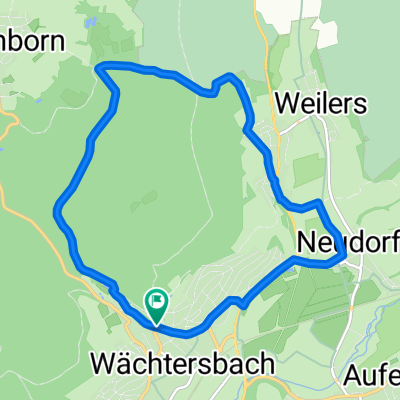
Wächtersbach - Lütter (Eichenzell)
A cycling route starting in Wächtersbach, Hesse, Germany.
Overview
About this route
Wächtersbach - Bad Soden - Schlüchtern - Flieden - Neuhof - Eichenzell - Lütter
- -:--
- Duration
- 54.6 km
- Distance
- 426 m
- Ascent
- 257 m
- Descent
- ---
- Avg. speed
- ---
- Max. altitude

Part of
Himmelfahrt 2018
4 stages
Route quality
Waytypes & surfaces along the route
Waytypes
Track
19.1 km
(35 %)
Quiet road
11.5 km
(21 %)
Surfaces
Paved
47.5 km
(87 %)
Unpaved
3.8 km
(7 %)
Asphalt
42.6 km
(78 %)
Concrete
3.3 km
(6 %)
Continue with Bikemap
Use, edit, or download this cycling route
You would like to ride Wächtersbach - Lütter (Eichenzell) or customize it for your own trip? Here is what you can do with this Bikemap route:
Free features
- Save this route as favorite or in collections
- Copy & plan your own version of this route
- Sync your route with Garmin or Wahoo
Premium features
Free trial for 3 days, or one-time payment. More about Bikemap Premium.
- Navigate this route on iOS & Android
- Export a GPX / KML file of this route
- Create your custom printout (try it for free)
- Download this route for offline navigation
Discover more Premium features.
Get Bikemap PremiumFrom our community
Other popular routes starting in Wächtersbach
 Wächtersbach - Wittgenborn (kleine Runde)
- Distance
- 10 km
- Ascent
- 213 m
- Descent
- 226 m
- Location
- Wächtersbach, Hesse, Germany
 Spessart-Wald-Runde
- Distance
- 41 km
- Ascent
- 625 m
- Descent
- 415 m
- Location
- Wächtersbach, Hesse, Germany
 Wächtersbach - Stausee
- Distance
- 30.3 km
- Ascent
- 162 m
- Descent
- 163 m
- Location
- Wächtersbach, Hesse, Germany
 Pfingstrunde-Aufenau-Obermoos-Radmühl-Aufenau
- Distance
- 72 km
- Ascent
- 471 m
- Descent
- 470 m
- Location
- Wächtersbach, Hesse, Germany
 Katerrunde
- Distance
- 54 km
- Ascent
- 336 m
- Descent
- 336 m
- Location
- Wächtersbach, Hesse, Germany
 1997 Wächtersbach-Wern Tal
- Distance
- 77.3 km
- Ascent
- 552 m
- Descent
- 525 m
- Location
- Wächtersbach, Hesse, Germany
 Südbahnradweg und Apfelweinroute
- Distance
- 49.5 km
- Ascent
- 491 m
- Descent
- 491 m
- Location
- Wächtersbach, Hesse, Germany
 Auf-Schlier-Hellst-Udenh-Kätwill-BSS-Auf
- Distance
- 25.9 km
- Ascent
- 219 m
- Descent
- 217 m
- Location
- Wächtersbach, Hesse, Germany
Open it in the app