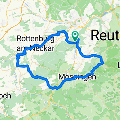
Dußlingen_Dreifürstenstein_47km_1100Hm
A cycling route starting in Dußlingen, Baden-Württemberg, Germany.
Overview
About this route
Anspruchsvolle Tour mit einigen zum Teil schwierigen Singletrails am Albtrauf
- -:--
- Duration
- 48.4 km
- Distance
- 767 m
- Ascent
- 767 m
- Descent
- ---
- Avg. speed
- ---
- Max. altitude
Continue with Bikemap
Use, edit, or download this cycling route
You would like to ride Dußlingen_Dreifürstenstein_47km_1100Hm or customize it for your own trip? Here is what you can do with this Bikemap route:
Free features
- Save this route as favorite or in collections
- Copy & plan your own version of this route
- Sync your route with Garmin or Wahoo
Premium features
Free trial for 3 days, or one-time payment. More about Bikemap Premium.
- Navigate this route on iOS & Android
- Export a GPX / KML file of this route
- Create your custom printout (try it for free)
- Download this route for offline navigation
Discover more Premium features.
Get Bikemap PremiumFrom our community
Other popular routes starting in Dußlingen
- Härten Spitzberg Tour 37km
- Distance
- 36.8 km
- Ascent
- 479 m
- Descent
- 489 m
- Location
- Dußlingen, Baden-Württemberg, Germany
- Training 1.5.'08
- Distance
- 57.9 km
- Ascent
- 432 m
- Descent
- 430 m
- Location
- Dußlingen, Baden-Württemberg, Germany
- Trainingsrunde Alb (Talheimer Steige)
- Distance
- 74 km
- Ascent
- 799 m
- Descent
- 784 m
- Location
- Dußlingen, Baden-Württemberg, Germany
- Schwäbische Alb
- Distance
- 88.1 km
- Ascent
- 602 m
- Descent
- 608 m
- Location
- Dußlingen, Baden-Württemberg, Germany
- APR-24-21 Neckartal, Eyachtal bergig
- Distance
- 138.7 km
- Ascent
- 2,199 m
- Descent
- 2,159 m
- Location
- Dußlingen, Baden-Württemberg, Germany
- Dußlingen_Dreifürstenstein_47km_1100Hm
- Distance
- 48.4 km
- Ascent
- 767 m
- Descent
- 767 m
- Location
- Dußlingen, Baden-Württemberg, Germany
- Dußlingen und die Nachbarorte
- Distance
- 24.9 km
- Ascent
- 134 m
- Descent
- 136 m
- Location
- Dußlingen, Baden-Württemberg, Germany
- Glatt Schloßcafe
- Distance
- 91.1 km
- Ascent
- 1,642 m
- Descent
- 1,645 m
- Location
- Dußlingen, Baden-Württemberg, Germany
Open it in the app