

RSLC/ équipe vélo Frühjahr ,lang, Steinsee
A cycling route starting in Holzkirchen, Bavaria, Germany.
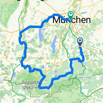
Overview
About this route
- -:--
- Duration
- 73.5 km
- Distance
- 251 m
- Ascent
- 252 m
- Descent
- ---
- Avg. speed
- ---
- Max. altitude

Route quality
Waytypes & surfaces along the route
Waytypes
Quiet road
24.4 km
(33 %)
Road
23.8 km
(32 %)
Surfaces
Paved
72.2 km
(98 %)
Unpaved
0.5 km
(<1 %)
Asphalt
71.5 km
(97 %)
Paving stones
0.6 km
(<1 %)
Continue with Bikemap
Use, edit, or download this cycling route
You would like to ride RSLC/ équipe vélo Frühjahr ,lang, Steinsee or customize it for your own trip? Here is what you can do with this Bikemap route:
Free features
- Save this route as favorite or in collections
- Copy & plan your own version of this route
- Sync your route with Garmin or Wahoo
Premium features
Free trial for 3 days, or one-time payment. More about Bikemap Premium.
- Navigate this route on iOS & Android
- Export a GPX / KML file of this route
- Create your custom printout (try it for free)
- Download this route for offline navigation
Discover more Premium features.
Get Bikemap PremiumFrom our community
Other popular routes starting in Holzkirchen
 Feierabendrunde Hoki-Kirchsee-Bairawies-Hoki
- Distance
- 43.3 km
- Ascent
- 405 m
- Descent
- 394 m
- Location
- Holzkirchen, Bavaria, Germany
 Holzkirchen Bahnhof - Bad Tölz - Holzkirchen Bahnhof
- Distance
- 53.5 km
- Ascent
- 650 m
- Descent
- 628 m
- Location
- Holzkirchen, Bavaria, Germany
 Holzkirchen nach Miesbach Krauthof Café über Höfe zurück
- Distance
- 46.5 km
- Ascent
- 781 m
- Descent
- 779 m
- Location
- Holzkirchen, Bavaria, Germany
 Marktplatz Holzkirchen nach Gmund, Holzkirchen
- Distance
- 39.1 km
- Ascent
- 784 m
- Descent
- 786 m
- Location
- Holzkirchen, Bavaria, Germany
 GOC Holzkirchen-Bad Tölz
- Distance
- 56.6 km
- Ascent
- 614 m
- Descent
- 584 m
- Location
- Holzkirchen, Bavaria, Germany
 Kultur-Rad-Tour 2025
- Distance
- 298.5 km
- Ascent
- 3,017 m
- Descent
- 3,179 m
- Location
- Holzkirchen, Bavaria, Germany
 Holzkirchen nach Miesbach Krauthof Café über Höfe zurück
- Distance
- 45.7 km
- Ascent
- 528 m
- Descent
- 528 m
- Location
- Holzkirchen, Bavaria, Germany
 Gemütliche Alpenvorlandsstrecke
- Distance
- 39.6 km
- Ascent
- 357 m
- Descent
- 357 m
- Location
- Holzkirchen, Bavaria, Germany
Open it in the app