
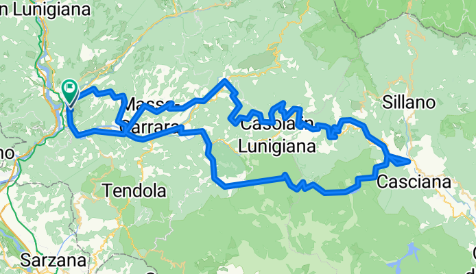
Aulla-Fivizzano-Carpinelli-Giuncagnano-Piazza al Serchio-Equi Terme-Aulla
A cycling route starting in Aulla, Tuscany, Italy.
Overview
About this route
Dalla stazione di Aulla si raggiunge Fivizzano, passando per Piani di Collecchia, Moncigoli, Ponte di Posara.
Si continua per Serrarola, Terenzano, Reusa, Castiglioncello. Qui la strada sale per circa 7 km fino a Casone Carpinelli.
Si prosegue per Giuncagnano percorrendo anche un tratto sterrato dopo il camping Argegna. Ora si scende, con qualche tratto anche sterrato, fino al Borgo di San Michele; lo attraversiamo e arriviamo a Piazza al serchio.
Si torna verso ovest, raggiungedo il lago di Gramolazzo. Ci attendono 7 km di salita in direzione Ugliancaldo. Poco prima del paese un sentiero sterrato di circa 2 km ci porta ad Equi Terme (il tratto è prevalentemente in discesa). Visita della magnifiche Grotte e, se aperte, un bagno alle terme, prima di raggiungere nuovamente Aulla.
Giro ottimo in due giorni
- -:--
- Duration
- 97.2 km
- Distance
- 1,531 m
- Ascent
- 1,538 m
- Descent
- ---
- Avg. speed
- ---
- Max. altitude
Route quality
Waytypes & surfaces along the route
Waytypes
Road
42.5 km
(44 %)
Busy road
18.5 km
(19 %)
Surfaces
Paved
32.4 km
(33 %)
Unpaved
14.5 km
(15 %)
Asphalt
31.3 km
(32 %)
Ground
12.4 km
(13 %)
Continue with Bikemap
Use, edit, or download this cycling route
You would like to ride Aulla-Fivizzano-Carpinelli-Giuncagnano-Piazza al Serchio-Equi Terme-Aulla or customize it for your own trip? Here is what you can do with this Bikemap route:
Free features
- Save this route as favorite or in collections
- Copy & plan your own version of this route
- Split it into stages to create a multi-day tour
- Sync your route with Garmin or Wahoo
Premium features
Free trial for 3 days, or one-time payment. More about Bikemap Premium.
- Navigate this route on iOS & Android
- Export a GPX / KML file of this route
- Create your custom printout (try it for free)
- Download this route for offline navigation
Discover more Premium features.
Get Bikemap PremiumFrom our community
Other popular routes starting in Aulla
 Aulla Stazione - Equi Terme - Pieve san Lorenzo - Gramolazzo
- Distance
- 50.5 km
- Ascent
- 908 m
- Descent
- 361 m
- Location
- Aulla, Tuscany, Italy
 aulla - zona francigena
- Distance
- 26.3 km
- Ascent
- ---
- Descent
- ---
- Location
- Aulla, Tuscany, Italy
 aulla francigena
- Distance
- 50.3 km
- Ascent
- ---
- Descent
- ---
- Location
- Aulla, Tuscany, Italy
 giro montemarcello da aulla
- Distance
- 66.3 km
- Ascent
- 1,117 m
- Descent
- 1,118 m
- Location
- Aulla, Tuscany, Italy
 14. etappe
- Distance
- 98 km
- Ascent
- 35 m
- Descent
- 86 m
- Location
- Aulla, Tuscany, Italy
 Aulla-AVML-Calice al C-Aulla
- Distance
- 42 km
- Ascent
- 1,112 m
- Descent
- 1,107 m
- Location
- Aulla, Tuscany, Italy
 Aulla-Bagnone-Pontremoli-Tresana-Aulla
- Distance
- 74.7 km
- Ascent
- 1,043 m
- Descent
- 1,039 m
- Location
- Aulla, Tuscany, Italy
 Aulla-Fivizzano-Casola Lunigiana-Equi Terme-Aulla
- Distance
- 78.6 km
- Ascent
- 1,143 m
- Descent
- 1,145 m
- Location
- Aulla, Tuscany, Italy
Open it in the app