

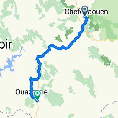
CHEZCHAOUEN-FÈS
A cycling route starting in Chefchaouen, Région de Tanger-Tétouan, Morocco.
Overview
About this route
- -:--
- Duration
- 352.9 km
- Distance
- 3,593 m
- Ascent
- 2,943 m
- Descent
- ---
- Avg. speed
- ---
- Max. altitude

Route quality
Waytypes & surfaces along the route
Waytypes
Road
105.9 km
(30 %)
Quiet road
45.9 km
(13 %)
Surfaces
Paved
243.5 km
(69 %)
Unpaved
3.5 km
(1 %)
Asphalt
243.5 km
(69 %)
Unpaved (undefined)
3.5 km
(1 %)
Undefined
105.9 km
(30 %)
Continue with Bikemap
Use, edit, or download this cycling route
You would like to ride CHEZCHAOUEN-FÈS or customize it for your own trip? Here is what you can do with this Bikemap route:
Free features
- Save this route as favorite or in collections
- Copy & plan your own version of this route
- Split it into stages to create a multi-day tour
- Sync your route with Garmin or Wahoo
Premium features
Free trial for 3 days, or one-time payment. More about Bikemap Premium.
- Navigate this route on iOS & Android
- Export a GPX / KML file of this route
- Create your custom printout (try it for free)
- Download this route for offline navigation
Discover more Premium features.
Get Bikemap PremiumFrom our community
Other popular routes starting in Chefchaouen
 chefchaouen-fes
- Distance
- 203.2 km
- Ascent
- 1,142 m
- Descent
- 1,337 m
- Location
- Chefchaouen, Région de Tanger-Tétouan, Morocco
 Maroc - Akchour-Camping Chefchaouen
- Distance
- 19.1 km
- Ascent
- 725 m
- Descent
- 410 m
- Location
- Chefchaouen, Région de Tanger-Tétouan, Morocco
 Maroko II
- Distance
- 103.1 km
- Ascent
- 655 m
- Descent
- 1,219 m
- Location
- Chefchaouen, Région de Tanger-Tétouan, Morocco
 MS22 Chefchaouen - Martil
- Distance
- 74.2 km
- Ascent
- 448 m
- Descent
- 1,038 m
- Location
- Chefchaouen, Région de Tanger-Tétouan, Morocco
 M1 Day 03 ChefChaouen Hotel Rif 48.5 mls 960up
- Distance
- 78.4 km
- Ascent
- 1,259 m
- Descent
- 1,568 m
- Location
- Chefchaouen, Région de Tanger-Tétouan, Morocco
 avenue des FAR،, Chefchaouen to Rue Recteur Daure 7, Caen
- Distance
- 2,410.2 km
- Ascent
- 25,923 m
- Descent
- 26,505 m
- Location
- Chefchaouen, Région de Tanger-Tétouan, Morocco
 Maroka 4.11
- Distance
- 84.4 km
- Ascent
- 950 m
- Descent
- 1,229 m
- Location
- Chefchaouen, Région de Tanger-Tétouan, Morocco
 Maroc - Chefchauen-Pont de Dieu
- Distance
- 28.2 km
- Ascent
- 1,419 m
- Descent
- 1,551 m
- Location
- Chefchaouen, Région de Tanger-Tétouan, Morocco
Open it in the app