

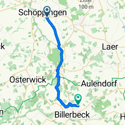
Die Baumberge en Schöppinger Berg - 1
A cycling route starting in Schöppingen, North Rhine-Westphalia, Germany.
Overview
About this route
Full route taken from www.routeyou.com/nl
- -:--
- Duration
- 112.3 km
- Distance
- 671 m
- Ascent
- 671 m
- Descent
- ---
- Avg. speed
- ---
- Max. altitude

Route quality
Waytypes & surfaces along the route
Waytypes
Quiet road
70.8 km
(63 %)
Road
20.2 km
(18 %)
Surfaces
Paved
56.2 km
(50 %)
Asphalt
52.8 km
(47 %)
Paved (undefined)
3.4 km
(3 %)
Undefined
56.2 km
(50 %)
Continue with Bikemap
Use, edit, or download this cycling route
You would like to ride Die Baumberge en Schöppinger Berg - 1 or customize it for your own trip? Here is what you can do with this Bikemap route:
Free features
- Save this route as favorite or in collections
- Copy & plan your own version of this route
- Split it into stages to create a multi-day tour
- Sync your route with Garmin or Wahoo
Premium features
Free trial for 3 days, or one-time payment. More about Bikemap Premium.
- Navigate this route on iOS & Android
- Export a GPX / KML file of this route
- Create your custom printout (try it for free)
- Download this route for offline navigation
Discover more Premium features.
Get Bikemap PremiumFrom our community
Other popular routes starting in Schöppingen
 Ebbinghoff nach Mergelkamp
- Distance
- 15.6 km
- Ascent
- 181 m
- Descent
- 168 m
- Location
- Schöppingen, North Rhine-Westphalia, Germany
 Radtour 2009 - 3. Tag
- Distance
- 74.5 km
- Ascent
- 188 m
- Descent
- 197 m
- Location
- Schöppingen, North Rhine-Westphalia, Germany
 Schoppingen-Telgte boven Munster-82km
- Distance
- 81.6 km
- Ascent
- 103 m
- Descent
- 132 m
- Location
- Schöppingen, North Rhine-Westphalia, Germany
 kleine Aulendorfrunde
- Distance
- 39.2 km
- Ascent
- 168 m
- Descent
- 171 m
- Location
- Schöppingen, North Rhine-Westphalia, Germany
 Schöppingen-Enschede NL - Schöppingen
- Distance
- 79.3 km
- Ascent
- 195 m
- Descent
- 168 m
- Location
- Schöppingen, North Rhine-Westphalia, Germany
 Die Baumberge en Schöppinger Berg - 1
- Distance
- 112.3 km
- Ascent
- 671 m
- Descent
- 671 m
- Location
- Schöppingen, North Rhine-Westphalia, Germany
 Münsterlandtour Tag 1
- Distance
- 55.5 km
- Ascent
- 190 m
- Descent
- 192 m
- Location
- Schöppingen, North Rhine-Westphalia, Germany
 Hauptstraße, Schöppingen nach Eper Straße, Ahaus
- Distance
- 88.2 km
- Ascent
- 157 m
- Descent
- 196 m
- Location
- Schöppingen, North Rhine-Westphalia, Germany
Open it in the app