

St-Maurice - Champoussin
A cycling route starting in Saint-Maurice, Valais, Switzerland.
Overview
About this route
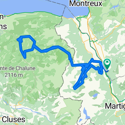
Departure from St-Maurice towards Masongex. Climb to Vérossaz and then to the Giettes. Descent towards Choëx and then a fork onto the Rives road towards Champéry. Climb to Champoussin and then descent to Val d'Illiez. Fork onto the forest road to Morgins. In Morgins, take the main road to Monthey and return to St-Maurice.
- -:--
- Duration
- 80.3 km
- Distance
- 2,105 m
- Ascent
- 2,105 m
- Descent
- ---
- Avg. speed
- ---
- Max. altitude

Route quality
Waytypes & surfaces along the route
Waytypes
Quiet road
35.3 km
(44 %)
Road
23.3 km
(29 %)
Surfaces
Paved
22.5 km
(28 %)
Unpaved
1.6 km
(2 %)
Asphalt
21.7 km
(27 %)
Gravel
1.6 km
(2 %)
Continue with Bikemap
Use, edit, or download this cycling route
You would like to ride St-Maurice - Champoussin or customize it for your own trip? Here is what you can do with this Bikemap route:
Free features
- Save this route as favorite or in collections
- Copy & plan your own version of this route
- Split it into stages to create a multi-day tour
- Sync your route with Garmin or Wahoo
Premium features
Free trial for 3 days, or one-time payment. More about Bikemap Premium.
- Navigate this route on iOS & Android
- Export a GPX / KML file of this route
- Create your custom printout (try it for free)
- Download this route for offline navigation
Discover more Premium features.
Get Bikemap PremiumFrom our community
Other popular routes starting in Saint-Maurice
 Abondance des grimpeurs
- Distance
- 144.1 km
- Ascent
- 2,919 m
- Descent
- 2,905 m
- Location
- Saint-Maurice, Valais, Switzerland
 SIC D1 - afternoon ride - local climbs
- Distance
- 25.1 km
- Ascent
- 506 m
- Descent
- 502 m
- Location
- Saint-Maurice, Valais, Switzerland
 St-Maurice - Champoussin
- Distance
- 80.3 km
- Ascent
- 2,105 m
- Descent
- 2,105 m
- Location
- Saint-Maurice, Valais, Switzerland
 retour pélerinage de sauvage
- Distance
- 91.4 km
- Ascent
- 703 m
- Descent
- 503 m
- Location
- Saint-Maurice, Valais, Switzerland
 St-Maurice - Sonchaux - Caux - St-Maurice
- Distance
- 91.8 km
- Ascent
- 1,563 m
- Descent
- 1,562 m
- Location
- Saint-Maurice, Valais, Switzerland
 Tour de Abondance - in reverse
- Distance
- 118.5 km
- Ascent
- 1,423 m
- Descent
- 1,420 m
- Location
- Saint-Maurice, Valais, Switzerland
 Val d'Illiez (La Barme)
- Distance
- 67.9 km
- Ascent
- 1,562 m
- Descent
- 1,565 m
- Location
- Saint-Maurice, Valais, Switzerland
 Morcles, et plus si entente...
- Distance
- 10.1 km
- Ascent
- 1,238 m
- Descent
- 146 m
- Location
- Saint-Maurice, Valais, Switzerland
Open it in the app