

Nordenstadt - Steinkopf - Nordenstadt
A cycling route starting in Hochheim am Main, Hesse, Germany.
Overview
About this route
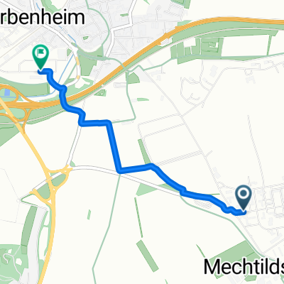
The tour starts in Nordenstadt and leads through the fields, first passing Igstadt and then Kloppenheim. From Kloppenheim, it goes constantly uphill until reaching the approximately 330 m high Steinkopf. Afterwards, the route goes through the forest and over a winding and very beautiful descent back to the country road. Attention, in some places the curves are not well visible. On the country road, the journey continues towards Hockenberger Mill. From there, it goes back through a very nice piece of forest towards Igstadt and then further on to Nordenstadt.
- -:--
- Duration
- 23 km
- Distance
- 298 m
- Ascent
- 303 m
- Descent
- ---
- Avg. speed
- 348 m
- Max. altitude
Route quality
Waytypes & surfaces along the route
Waytypes
Track
17 km
(74 %)
Road
3.9 km
(17 %)
Surfaces
Paved
14 km
(61 %)
Unpaved
6 km
(26 %)
Paved (undefined)
7.1 km
(31 %)
Asphalt
5.5 km
(24 %)
Continue with Bikemap
Use, edit, or download this cycling route
You would like to ride Nordenstadt - Steinkopf - Nordenstadt or customize it for your own trip? Here is what you can do with this Bikemap route:
Free features
- Save this route as favorite or in collections
- Copy & plan your own version of this route
- Sync your route with Garmin or Wahoo
Premium features
Free trial for 3 days, or one-time payment. More about Bikemap Premium.
- Navigate this route on iOS & Android
- Export a GPX / KML file of this route
- Create your custom printout (try it for free)
- Download this route for offline navigation
Discover more Premium features.
Get Bikemap PremiumFrom our community
Other popular routes starting in Hochheim am Main
 Wiesbaden Centre, Wiesbaden to Zur Schleifmühle, Wiesbaden
- Distance
- 2.9 km
- Ascent
- 7 m
- Descent
- 3 m
- Location
- Hochheim am Main, Hesse, Germany
 Wi-Erbenheim nach Eltville/Rhein
- Distance
- 26.3 km
- Ascent
- 95 m
- Descent
- 196 m
- Location
- Hochheim am Main, Hesse, Germany
 Homestead Route
- Distance
- 18.1 km
- Ascent
- 160 m
- Descent
- 158 m
- Location
- Hochheim am Main, Hesse, Germany
 Nordenstadt-Breckenheim-Bremthal-Auringen
- Distance
- 28 km
- Ascent
- 284 m
- Descent
- 281 m
- Location
- Hochheim am Main, Hesse, Germany
 kleine Rheinrunde von Mainz bis Oestrich
- Distance
- 48.6 km
- Ascent
- 80 m
- Descent
- 76 m
- Location
- Hochheim am Main, Hesse, Germany
 Hochheim Eppstein Runde
- Distance
- 49.2 km
- Ascent
- 478 m
- Descent
- 471 m
- Location
- Hochheim am Main, Hesse, Germany
 The Little Dipper
- Distance
- 19.2 km
- Ascent
- 266 m
- Descent
- 263 m
- Location
- Hochheim am Main, Hesse, Germany
 Daily "short" route
- Distance
- 10.5 km
- Ascent
- 43 m
- Descent
- 42 m
- Location
- Hochheim am Main, Hesse, Germany
Open it in the app