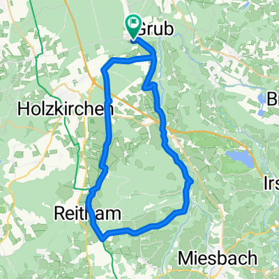
BR 003: (Stuttgart - München Hbf -) Kreuzstraße - Brannenburg
A cycling route starting in Valley, Bavaria, Germany.
Overview
About this route
(München Hbf. -) S-Bhf. Kreuzstr. - Rosenheimer Str./MB 4 - Aschbach - D11/Mangfall - Bad Aibling - D11/Mangfall - Kolbermoor - Carl-Jordan-Str. - Mitterhardt - Schlipfham - Westerndorf - Sporthrim Nicklheim - Großholzhausen - BRANNENBURG/ Pension Berghof
- -:--
- Duration
- 43.9 km
- Distance
- 136 m
- Ascent
- 240 m
- Descent
- ---
- Avg. speed
- ---
- Avg. speed
Route quality
Waytypes & surfaces along the route
Waytypes
Quiet road
19.6 km
(45 %)
Path
14.6 km
(33 %)
Surfaces
Paved
32.7 km
(74 %)
Unpaved
11.2 km
(25 %)
Asphalt
32 km
(73 %)
Loose gravel
9.2 km
(21 %)
Route highlights
Points of interest along the route
Drinking water after 25 km
Mangfall
Point of interest after 43.5 km
Schloßwirt
Continue with Bikemap
Use, edit, or download this cycling route
You would like to ride BR 003: (Stuttgart - München Hbf -) Kreuzstraße - Brannenburg or customize it for your own trip? Here is what you can do with this Bikemap route:
Free features
- Save this route as favorite or in collections
- Copy & plan your own version of this route
- Sync your route with Garmin or Wahoo
Premium features
Free trial for 3 days, or one-time payment. More about Bikemap Premium.
- Navigate this route on iOS & Android
- Export a GPX / KML file of this route
- Create your custom printout (try it for free)
- Download this route for offline navigation
Discover more Premium features.
Get Bikemap PremiumFrom our community
Other popular routes starting in Valley
- Unterdarching zum Tegernsee, M-Wasserweg
- Distance
- 44.7 km
- Ascent
- 635 m
- Descent
- 637 m
- Location
- Valley, Bavaria, Germany
- BR 003: (Stuttgart - München Hbf -) Kreuzstraße - Brannenburg
- Distance
- 43.9 km
- Ascent
- 136 m
- Descent
- 240 m
- Location
- Valley, Bavaria, Germany
- Grubmühle - Maxlmühle, an der Mangfall
- Distance
- 18.8 km
- Ascent
- 549 m
- Descent
- 547 m
- Location
- Valley, Bavaria, Germany
- Kreuzstraße - Spitzing - Kreuzstraße
- Distance
- 103.6 km
- Ascent
- 1,433 m
- Descent
- 1,447 m
- Location
- Valley, Bavaria, Germany
- Valley - Tegernsee - Rundtour
- Distance
- 65.5 km
- Ascent
- 949 m
- Descent
- 946 m
- Location
- Valley, Bavaria, Germany
- Kreuzstraße - Sudelfeld - Kreuzstraße
- Distance
- 116.7 km
- Ascent
- 1,616 m
- Descent
- 1,713 m
- Location
- Valley, Bavaria, Germany
- 1988_Kreuzstraße_Holzkirchen (Radlrallye)
- Distance
- 27 km
- Ascent
- 118 m
- Descent
- 119 m
- Location
- Valley, Bavaria, Germany
- 13.03.02 Kl. Mangfalltalwanderung von Hohendilching nach Grub
- Distance
- 5.6 km
- Ascent
- 152 m
- Descent
- 154 m
- Location
- Valley, Bavaria, Germany
Open it in the app