
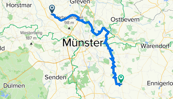
Altenberge nach Sendenhorst, Himmelreich
A cycling route starting in Altenberge, North Rhine-Westphalia, Germany.
Overview
About this route
Fahrradtour zum Einstieg in eine Ferienfreizeit mit Grundschulkindern
- -:--
- Duration
- 58 km
- Distance
- 184 m
- Ascent
- 193 m
- Descent
- ---
- Avg. speed
- 73 m
- Avg. speed

Route quality
Waytypes & surfaces along the route
Waytypes
Quiet road
36.4 km
(63 %)
Path
9.5 km
(16 %)
Surfaces
Paved
46.5 km
(80 %)
Unpaved
3.3 km
(6 %)
Asphalt
42.1 km
(73 %)
Gravel
3.1 km
(5 %)
Route highlights
Points of interest along the route
Point of interest after 9.5 km
kleine Pause: am Wald
Point of interest after 18.3 km
Große Pause: Rieselfelder
Point of interest after 27.9 km
kleine Pause an der Schranke
Point of interest after 33.7 km
kleine Pause: an der Hütte
Point of interest after 39.8 km
Große Pause: Flughafen Berdel
Point of interest after 52.3 km
kleine Pause: im Wald
Continue with Bikemap
Use, edit, or download this cycling route
You would like to ride Altenberge nach Sendenhorst, Himmelreich or customize it for your own trip? Here is what you can do with this Bikemap route:
Free features
- Save this route as favorite or in collections
- Copy & plan your own version of this route
- Sync your route with Garmin or Wahoo
Premium features
Free trial for 3 days, or one-time payment. More about Bikemap Premium.
- Navigate this route on iOS & Android
- Export a GPX / KML file of this route
- Create your custom printout (try it for free)
- Download this route for offline navigation
Discover more Premium features.
Get Bikemap PremiumFrom our community
Other popular routes starting in Altenberge
 Nienberge- Sprakel-Altenberge Aufnahme vom 20. Juli 14:35
- Distance
- 13.7 km
- Ascent
- 38 m
- Descent
- 78 m
- Location
- Altenberge, North Rhine-Westphalia, Germany
 Altenberge Burg-Hulshof Aufnahme vom 9. August 13:51
- Distance
- 26.3 km
- Ascent
- 87 m
- Descent
- 76 m
- Location
- Altenberge, North Rhine-Westphalia, Germany
 Altenberge -Max-Klemens-Kanal
- Distance
- 35.9 km
- Ascent
- 212 m
- Descent
- 212 m
- Location
- Altenberge, North Rhine-Westphalia, Germany
 Altenberge -> Ahlintel -> Altenberge
- Distance
- 37.6 km
- Ascent
- 25 m
- Descent
- 38 m
- Location
- Altenberge, North Rhine-Westphalia, Germany
 Altenberge -> Rieselfelder -> Altenberge
- Distance
- 47.1 km
- Ascent
- 74 m
- Descent
- 74 m
- Location
- Altenberge, North Rhine-Westphalia, Germany
 Ausflug Mama Papa
- Distance
- 48.8 km
- Ascent
- 880 m
- Descent
- 867 m
- Location
- Altenberge, North Rhine-Westphalia, Germany
 Altenberge - Nienberge Aufnahme vom 20. Juli 14:35
- Distance
- 13.9 km
- Ascent
- 39 m
- Descent
- 81 m
- Location
- Altenberge, North Rhine-Westphalia, Germany
 70,2 km - Schmedehausen-Ostbevern-Handorf-Altenberge
- Distance
- 70.2 km
- Ascent
- 82 m
- Descent
- 128 m
- Location
- Altenberge, North Rhine-Westphalia, Germany
Open it in the app