

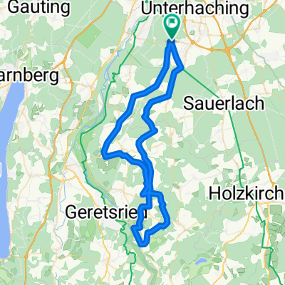
BR 001: Deisenhofen - Sauerlach - Kreuzstraße
A cycling route starting in Oberhaching, Bavaria, Germany.
Overview
About this route
(Munich Hbf -) S-Bhf DEISENHOFEN - VJ - SAUERLACH (S-Bhf) - St2070 - VBT/VJ - VJ - M9 - Kleinkarolinenfeld - M9 - Kreuzstraße (S-Bhf) (- BR 003)
- -:--
- Duration
- 19.7 km
- Distance
- 53 m
- Ascent
- 17 m
- Descent
- ---
- Avg. speed
- ---
- Max. altitude
Route quality
Waytypes & surfaces along the route
Waytypes
Track
7.9 km
(40 %)
Quiet road
4.5 km
(23 %)
Surfaces
Paved
15.8 km
(80 %)
Unpaved
3.8 km
(19 %)
Asphalt
15.8 km
(80 %)
Gravel
3.8 km
(19 %)
Undefined
0.2 km
(1 %)
Route highlights
Points of interest along the route
Accommodation after 19.7 km
Resorthotel Chalet Valley Boardinghouse
Continue with Bikemap
Use, edit, or download this cycling route
You would like to ride BR 001: Deisenhofen - Sauerlach - Kreuzstraße or customize it for your own trip? Here is what you can do with this Bikemap route:
Free features
- Save this route as favorite or in collections
- Copy & plan your own version of this route
- Sync your route with Garmin or Wahoo
Premium features
Free trial for 3 days, or one-time payment. More about Bikemap Premium.
- Navigate this route on iOS & Android
- Export a GPX / KML file of this route
- Create your custom printout (try it for free)
- Download this route for offline navigation
Discover more Premium features.
Get Bikemap PremiumFrom our community
Other popular routes starting in Oberhaching
 afterwork
- Distance
- 64.9 km
- Ascent
- 489 m
- Descent
- 491 m
- Location
- Oberhaching, Bavaria, Germany
 RC03 ObRunde 4
- Distance
- 35.4 km
- Ascent
- 239 m
- Descent
- 239 m
- Location
- Oberhaching, Bavaria, Germany
 12.10.17 Mühlthal-Fahrt
- Distance
- 30.1 km
- Ascent
- 172 m
- Descent
- 208 m
- Location
- Oberhaching, Bavaria, Germany
 Münchner Süden 02
- Distance
- 96 km
- Ascent
- 573 m
- Descent
- 573 m
- Location
- Oberhaching, Bavaria, Germany
 Deisenhofen-Egling
- Distance
- 63.6 km
- Ascent
- 710 m
- Descent
- 709 m
- Location
- Oberhaching, Bavaria, Germany
 Deisenhofen - Puppling
- Distance
- 52.8 km
- Ascent
- 340 m
- Descent
- 339 m
- Location
- Oberhaching, Bavaria, Germany
 Hubertusstraße, Oberhaching nach Tisinstraße, Oberhaching
- Distance
- 0.5 km
- Ascent
- 5 m
- Descent
- 9 m
- Location
- Oberhaching, Bavaria, Germany
 Oberlandtour 01
- Distance
- 53 km
- Ascent
- 400 m
- Descent
- 370 m
- Location
- Oberhaching, Bavaria, Germany
Open it in the app