

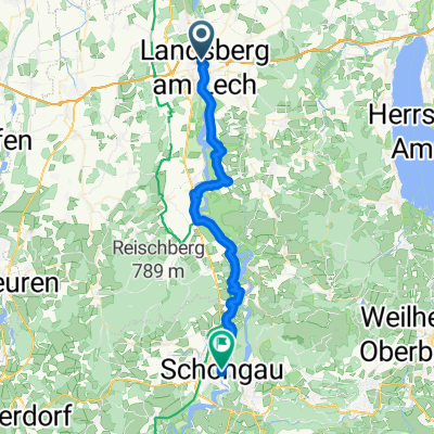
Fuchstalrunde allein
A cycling route starting in Landsberg am Lech, Bavaria, Germany.
Overview
About this route
On very good bike paths through fields and meadows and passing by attractions
- -:--
- Duration
- 38.5 km
- Distance
- 109 m
- Ascent
- 108 m
- Descent
- ---
- Avg. speed
- ---
- Max. altitude
Route quality
Waytypes & surfaces along the route
Waytypes
Track
17.3 km
(45 %)
Path
7.7 km
(20 %)
Surfaces
Paved
35.8 km
(93 %)
Unpaved
2.3 km
(6 %)
Asphalt
35.8 km
(93 %)
Gravel
1.5 km
(4 %)
Continue with Bikemap
Use, edit, or download this cycling route
You would like to ride Fuchstalrunde allein or customize it for your own trip? Here is what you can do with this Bikemap route:
Free features
- Save this route as favorite or in collections
- Copy & plan your own version of this route
- Sync your route with Garmin or Wahoo
Premium features
Free trial for 3 days, or one-time payment. More about Bikemap Premium.
- Navigate this route on iOS & Android
- Export a GPX / KML file of this route
- Create your custom printout (try it for free)
- Download this route for offline navigation
Discover more Premium features.
Get Bikemap PremiumFrom our community
Other popular routes starting in Landsberg am Lech
 D9 durch Deutschland - Romantische Strasse - Weserradweg - Cuxhaven
- Distance
- 809.8 km
- Ascent
- 4,864 m
- Descent
- 5,442 m
- Location
- Landsberg am Lech, Bavaria, Germany
 Landsberg am Lech - Schongau
- Distance
- 39.1 km
- Ascent
- 518 m
- Descent
- 401 m
- Location
- Landsberg am Lech, Bavaria, Germany
 Landsberg - Epfach
- Distance
- 41.5 km
- Ascent
- 204 m
- Descent
- 204 m
- Location
- Landsberg am Lech, Bavaria, Germany
 48.039° N 10.866° W nach 48.039° N 10.867° W
- Distance
- 26 km
- Ascent
- 69 m
- Descent
- 73 m
- Location
- Landsberg am Lech, Bavaria, Germany
 Ammerseerunde
- Distance
- 73.8 km
- Ascent
- 332 m
- Descent
- 332 m
- Location
- Landsberg am Lech, Bavaria, Germany
 Hauptplatz nach Reichenstraße
- Distance
- 70.3 km
- Ascent
- 653 m
- Descent
- 439 m
- Location
- Landsberg am Lech, Bavaria, Germany
 2012 Landsberg - Kaltenberg - Landsberg
- Distance
- 51.5 km
- Ascent
- 260 m
- Descent
- 260 m
- Location
- Landsberg am Lech, Bavaria, Germany
 Lechhöhenweg-Rundweg
- Distance
- 43.8 km
- Ascent
- 274 m
- Descent
- 286 m
- Location
- Landsberg am Lech, Bavaria, Germany
Open it in the app