

Wikinger 1.Tag Tönning/Norderstapel
A cycling route starting in Tönning, Schleswig-Holstein, Germany.
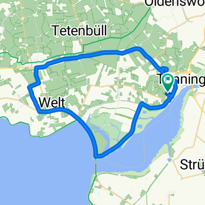
Overview
About this route
- -:--
- Duration
- 37.1 km
- Distance
- 15 m
- Ascent
- 13 m
- Descent
- ---
- Avg. speed
- ---
- Max. altitude
Route quality
Waytypes & surfaces along the route
Waytypes
Quiet road
23.8 km
(64 %)
Road
3 km
(8 %)
Surfaces
Paved
29.7 km
(80 %)
Asphalt
25.2 km
(68 %)
Concrete
3.7 km
(10 %)
Continue with Bikemap
Use, edit, or download this cycling route
You would like to ride Wikinger 1.Tag Tönning/Norderstapel or customize it for your own trip? Here is what you can do with this Bikemap route:
Free features
- Save this route as favorite or in collections
- Copy & plan your own version of this route
- Sync your route with Garmin or Wahoo
Premium features
Free trial for 3 days, or one-time payment. More about Bikemap Premium.
- Navigate this route on iOS & Android
- Export a GPX / KML file of this route
- Create your custom printout (try it for free)
- Download this route for offline navigation
Discover more Premium features.
Get Bikemap PremiumFrom our community
Other popular routes starting in Tönning
 Tönning-St.Peter Dorf
- Distance
- 29.2 km
- Ascent
- 0 m
- Descent
- 0 m
- Location
- Tönning, Schleswig-Holstein, Germany
 Tönning, Sperrwerk, Welt Garding, Tönning
- Distance
- 33.6 km
- Ascent
- 10 m
- Descent
- 10 m
- Location
- Tönning, Schleswig-Holstein, Germany
 Ederrundfahrt
- Distance
- 29.1 km
- Ascent
- 0 m
- Descent
- 0 m
- Location
- Tönning, Schleswig-Holstein, Germany
 Tönning nach St Peter 75 km
- Distance
- 76.6 km
- Ascent
- 4 m
- Descent
- 4 m
- Location
- Tönning, Schleswig-Holstein, Germany
 Nordseeküstenradweg 2015_Teil 4
- Distance
- 74.2 km
- Ascent
- 14 m
- Descent
- 11 m
- Location
- Tönning, Schleswig-Holstein, Germany
 Tönning - Katinger Watt - Westerhever - Tönning
- Distance
- 78.5 km
- Ascent
- 10 m
- Descent
- 10 m
- Location
- Tönning, Schleswig-Holstein, Germany
 awv52H4-Tönning-StPeter Ording H
- Distance
- 37.4 km
- Ascent
- 5 m
- Descent
- 6 m
- Location
- Tönning, Schleswig-Holstein, Germany
 Ostsee 12: Tönning-Meldorf 48,3km 0hm
- Distance
- 49.7 km
- Ascent
- 11 m
- Descent
- 9 m
- Location
- Tönning, Schleswig-Holstein, Germany
Open it in the app