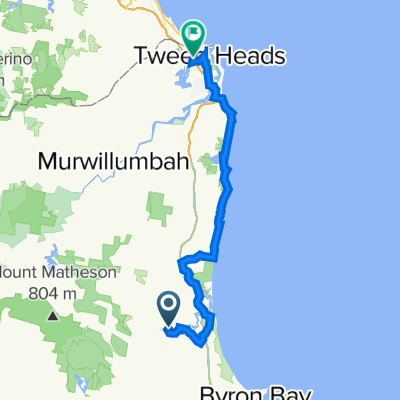
Brunswick to Tweed Beach and River Ride
- 44.3 km
- 97 m
- 97 m
- Brunswick Heads, New South Wales, Australia
A cycling route starting in Brunswick Heads, New South Wales, Australia.
Overview
Starting from a 'secret' beach this route takes you all along this great coast between the Brunswick River and the Tweed River.
Park in the little car park just off Rajah Road.
Before you set off, you can walk or bike to the beach (soft sand) a couple of hundred metres to the south. A quick dip there now, or if you do the return trip.
Head north the unpaved road on the river bank through New Brighton and into Ocean Shores.
You can cheat here, and take a flat (albeit sandy) route behind the dunes from the tip of Pacific Esplanade along the Billinugel Coast Trail. This is fine for a hybrid or tough road bike. Narrow tyres are no good.
Or stick to my route for a steep MTB climb up from Shara Blvd rising about 45m pretty sharpish. Then downhill, through amazingly varied flora on easy MTB track to Wooyung Road. Look out for big, fat swamp wallabies, black cockatoos and, if you are lucky, a beautiful red-bellied black sunning themselves.
Flat and easy most of the way now, with no rough or steep terrain. Nearly all bike path from Cabarita.
Grab an ice cream in Pottsville, detour up the hill to see the waves crashing and whales in winter at Hastings Point then behind the Multi-Million$ McMansions in Casuarina and Salt.
When you cross Cudgen Creek coming into Kingscliff, look up at the lights on the bridge. There is often big eagle sitting on the lamppost looking for dinner.
Keep to the right, along the river all the way - there is a nice cycle friendly boardwalk (one dismount crossing) and into Kingscliff proper.
Along the renovated seafront (2018) in Kingscliff - all on a bike path.
Follow the path to the left of the oval, to the river in Chinderah. Along the Tweed to Fingal.
Lock the bikes and go and look at Australia's own (mini) Giants Causeway and the old lighthouse.
Finish off (or get ready for the return if you didn't leave a spare car here) at Sheoak Shack Gallery Cafe.
Yummy grub on the way:
No camping allowed outside campsites on this whole route and the rangers go looking.
Enjoy!
created this 7 years ago

Route quality
Cycleway
20.8 km
(47 %)
Road
10.2 km
(23 %)
Paved
28.8 km
(65 %)
Unpaved
4 km
(9 %)
Paved (undefined)
21.7 km
(49 %)
Asphalt
7.1 km
(16 %)
Continue with Bikemap
You would like to ride Brunswick to Tweed Beach and River Ride or customize it for your own trip? Here is what you can do with this Bikemap route:
Free trial for 3 days, or one-time payment. More about Bikemap Premium.
Discover more Premium features.
Get Bikemap PremiumFrom our community
Open it in the app