

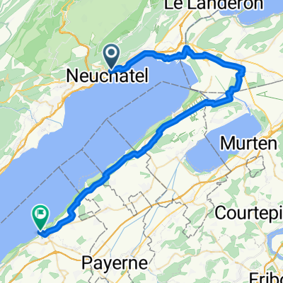
Cyklo 50
A cycling route starting in Neuchâtel, Canton of Neuchâtel, Switzerland.
Overview
About this route
Cyklo 50
- -:--
- Duration
- 3.1 km
- Distance
- 0 m
- Ascent
- 0 m
- Descent
- ---
- Avg. speed
- ---
- Max. altitude
Route quality
Waytypes & surfaces along the route
Waytypes
Cycleway
2.2 km
(72 %)
Access road
0.4 km
(13 %)
Surfaces
Paved
2.7 km
(87 %)
Asphalt
2.7 km
(87 %)
Undefined
0.4 km
(13 %)
Continue with Bikemap
Use, edit, or download this cycling route
You would like to ride Cyklo 50 or customize it for your own trip? Here is what you can do with this Bikemap route:
Free features
- Save this route as favorite or in collections
- Copy & plan your own version of this route
- Sync your route with Garmin or Wahoo
Premium features
Free trial for 3 days, or one-time payment. More about Bikemap Premium.
- Navigate this route on iOS & Android
- Export a GPX / KML file of this route
- Create your custom printout (try it for free)
- Download this route for offline navigation
Discover more Premium features.
Get Bikemap PremiumFrom our community
Other popular routes starting in Neuchâtel
 Creux du van
- Distance
- 60.8 km
- Ascent
- 1,263 m
- Descent
- 1,270 m
- Location
- Neuchâtel, Canton of Neuchâtel, Switzerland
 Valangin - Coffrane - Les Geneveys-sur-Coffrane - Les Hauts-Geneveys - Vue des Alpes - Les Hauts-Geneveys - Cernier - Dombresson - Villiers- Valangin
- Distance
- 35.1 km
- Ascent
- 657 m
- Descent
- 657 m
- Location
- Neuchâtel, Canton of Neuchâtel, Switzerland
 Von Neuenburg bis Balsthal
- Distance
- 107.9 km
- Ascent
- 1,029 m
- Descent
- 987 m
- Location
- Neuchâtel, Canton of Neuchâtel, Switzerland
 NeuenburgLa Rochelle 1
- Distance
- 900.2 km
- Ascent
- 7,352 m
- Descent
- 7,800 m
- Location
- Neuchâtel, Canton of Neuchâtel, Switzerland
 Entlang dem Ain (R. Stahel)
- Distance
- 329.5 km
- Ascent
- 3,387 m
- Descent
- 3,622 m
- Location
- Neuchâtel, Canton of Neuchâtel, Switzerland
 Snail-like route in Neuchâtel
- Distance
- 5.9 km
- Ascent
- 36 m
- Descent
- 36 m
- Location
- Neuchâtel, Canton of Neuchâtel, Switzerland
 Jura NE-Vallorbe
- Distance
- 76.4 km
- Ascent
- 1,526 m
- Descent
- 1,201 m
- Location
- Neuchâtel, Canton of Neuchâtel, Switzerland
 Neuchatel - Estavayer-le-Lac
- Distance
- 47.2 km
- Ascent
- 275 m
- Descent
- 320 m
- Location
- Neuchâtel, Canton of Neuchâtel, Switzerland
Open it in the app