

Giro di Neu Schallersdorf
A cycling route starting in Dobšice, South Moravian, Czechia.
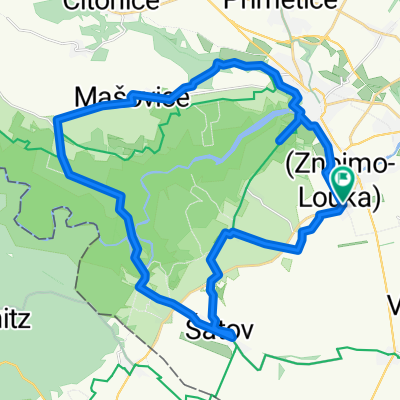
Overview
About this route
On the paths between the vineyards from/to New Šaldorf
- -:--
- Duration
- 36.9 km
- Distance
- 293 m
- Ascent
- 292 m
- Descent
- ---
- Avg. speed
- ---
- Max. altitude

Route quality
Waytypes & surfaces along the route
Waytypes
Track
17.7 km
(48 %)
Quiet road
8.9 km
(24 %)
Surfaces
Paved
9.6 km
(26 %)
Unpaved
11.1 km
(30 %)
Asphalt
5.9 km
(16 %)
Unpaved (undefined)
4.8 km
(13 %)
Route highlights
Points of interest along the route
Point of interest after 19.6 km
Moravské velvyslanecví v Rakousku
Photo after 25.3 km
Heilige Steine
Point of interest after 27.3 km
Vinný stánek
Point of interest after 31 km
Vinný stánek
Continue with Bikemap
Use, edit, or download this cycling route
You would like to ride Giro di Neu Schallersdorf or customize it for your own trip? Here is what you can do with this Bikemap route:
Free features
- Save this route as favorite or in collections
- Copy & plan your own version of this route
- Sync your route with Garmin or Wahoo
Premium features
Free trial for 3 days, or one-time payment. More about Bikemap Premium.
- Navigate this route on iOS & Android
- Export a GPX / KML file of this route
- Create your custom printout (try it for free)
- Download this route for offline navigation
Discover more Premium features.
Get Bikemap PremiumFrom our community
Other popular routes starting in Dobšice
 Nový Šaldorf
- Distance
- 45.9 km
- Ascent
- 294 m
- Descent
- 294 m
- Location
- Dobšice, South Moravian, Czechia
 16.09.15. Spain 02 AT
- Distance
- 685.8 km
- Ascent
- 3,624 m
- Descent
- 3,106 m
- Location
- Dobšice, South Moravian, Czechia
 Znojmo 9.8.2009
- Distance
- 39.9 km
- Ascent
- 347 m
- Descent
- 347 m
- Location
- Dobšice, South Moravian, Czechia
 Giro di Neu Schallersdorf
- Distance
- 36.9 km
- Ascent
- 293 m
- Descent
- 292 m
- Location
- Dobšice, South Moravian, Czechia
 Nový Šaldorf
- Distance
- 33.7 km
- Ascent
- 472 m
- Descent
- 472 m
- Location
- Dobšice, South Moravian, Czechia
 Seesfeld bez seesfeldu
- Distance
- 20.6 km
- Ascent
- 232 m
- Descent
- 226 m
- Location
- Dobšice, South Moravian, Czechia
 Nový Šaldorf
- Distance
- 43.9 km
- Ascent
- 393 m
- Descent
- 393 m
- Location
- Dobšice, South Moravian, Czechia
 Ze školy terénem...
- Distance
- 20.2 km
- Ascent
- 115 m
- Descent
- 149 m
- Location
- Dobšice, South Moravian, Czechia
Open it in the app