Trasa kolesarske dirke Poljane - Stari vrh
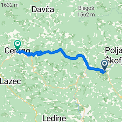
A cycling route starting in Gorenja Vas, Občina Gorenja vas-Poljane, Slovenia.
Overview
About this route
Route of the cycling race Poljane - Stari vrh
- -:--
- Duration
- 9.6 km
- Distance
- 654 m
- Ascent
- 72 m
- Descent
- ---
- Avg. speed
- 975 m
- Max. altitude
Route quality
Waytypes & surfaces along the route
Waytypes
Road
9.2 km
(96 %)
Quiet road
0.4 km
(4 %)
Surfaces
Paved
1.1 km
(11 %)
Asphalt
1.1 km
(11 %)
Undefined
8.5 km
(89 %)
Route highlights
Points of interest along the route
Point of interest after 0 km
Zaprti štart cestno gorske dirke Poljane - Stari vrh
Point of interest after 0 km
Leteči štart dirke
Point of interest after 9.6 km
Koča na Starem vrhu
Point of interest after 9.6 km
Cilj dirke na Grebljici pod Starim vrhom višina 978 m
Continue with Bikemap
Use, edit, or download this cycling route
You would like to ride Trasa kolesarske dirke Poljane - Stari vrh or customize it for your own trip? Here is what you can do with this Bikemap route:
Free features
- Save this route as favorite or in collections
- Copy & plan your own version of this route
- Sync your route with Garmin or Wahoo
Premium features
Free trial for 3 days, or one-time payment. More about Bikemap Premium.
- Navigate this route on iOS & Android
- Export a GPX / KML file of this route
- Create your custom printout (try it for free)
- Download this route for offline navigation
Discover more Premium features.
Get Bikemap PremiumFrom our community
Other popular routes starting in Gorenja Vas
2/3 gorenjevaškega kroga- Distance
- 78.9 km
- Ascent
- 2,182 m
- Descent
- 2,182 m
- Location
- Gorenja Vas, Občina Gorenja vas-Poljane, Slovenia
Gorenja Vas - Medvode- Distance
- 18.3 km
- Ascent
- 691 m
- Descent
- 765 m
- Location
- Gorenja Vas, Občina Gorenja vas-Poljane, Slovenia
Poljane nad Škofjo Loko - Blegoš- Distance
- 56.6 km
- Ascent
- 2,645 m
- Descent
- 2,662 m
- Location
- Gorenja Vas, Občina Gorenja vas-Poljane, Slovenia
Poljane - Žiri - Rovte - Logatec - Godovič - Idrija - Cerkno - Kladje - Poljane- Distance
- 109.6 km
- Ascent
- 2,085 m
- Descent
- 2,068 m
- Location
- Gorenja Vas, Občina Gorenja vas-Poljane, Slovenia
Dobje-Suhi Dol-Šentjošt-Žažar-Smrečje-Žiri-Dobje- Distance
- 56.9 km
- Ascent
- 1,086 m
- Descent
- 1,084 m
- Location
- Gorenja Vas, Občina Gorenja vas-Poljane, Slovenia
gorenje_brdo_-_crni_kal- Distance
- 8.2 km
- Ascent
- 518 m
- Descent
- 136 m
- Location
- Gorenja Vas, Občina Gorenja vas-Poljane, Slovenia
Poljane - Kranj - Naklo - Podnart - Kropa - Jamnik - Dražgoše - Železniki - Luša - Stari vrh - Javorje - Poljane- Distance
- 84.7 km
- Ascent
- 2,029 m
- Descent
- 1,894 m
- Location
- Gorenja Vas, Občina Gorenja vas-Poljane, Slovenia
Poljane - Lučine - Horjul - Podlipa - Žiri - Poljane- Distance
- 67.5 km
- Ascent
- 1,393 m
- Descent
- 1,365 m
- Location
- Gorenja Vas, Občina Gorenja vas-Poljane, Slovenia
Open it in the app


