

TA18E#7neuxx
A cycling route starting in Heiligenblut am Großglockner, Carinthia, Austria.
Overview
About this route
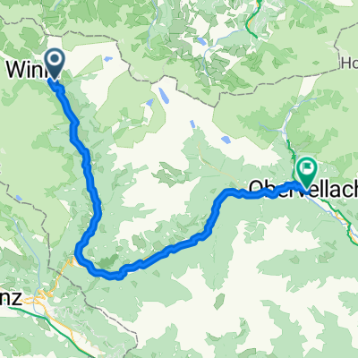
Heiligenblut-AlteGrossglocknerStrasse-Pasterze-Hochtor-Fusch
- -:--
- Duration
- 52.3 km
- Distance
- 1,751 m
- Ascent
- 2,161 m
- Descent
- ---
- Avg. speed
- ---
- Max. altitude
Route quality
Waytypes & surfaces along the route
Waytypes
Road
38.7 km
(74 %)
Quiet road
8.4 km
(16 %)
Surfaces
Paved
41.3 km
(79 %)
Asphalt
41.3 km
(79 %)
Undefined
11 km
(21 %)
Continue with Bikemap
Use, edit, or download this cycling route
You would like to ride TA18E#7neuxx or customize it for your own trip? Here is what you can do with this Bikemap route:
Free features
- Save this route as favorite or in collections
- Copy & plan your own version of this route
- Sync your route with Garmin or Wahoo
Premium features
Free trial for 3 days, or one-time payment. More about Bikemap Premium.
- Navigate this route on iOS & Android
- Export a GPX / KML file of this route
- Create your custom printout (try it for free)
- Download this route for offline navigation
Discover more Premium features.
Get Bikemap PremiumFrom our community
Other popular routes starting in Heiligenblut am Großglockner
 AT - Day 6 - Drauradweg
- Distance
- 66.9 km
- Ascent
- 734 m
- Descent
- 897 m
- Location
- Heiligenblut am Großglockner, Carinthia, Austria
 Heiligenblut - Berg im Drautal
- Distance
- 66.4 km
- Ascent
- 435 m
- Descent
- 1,065 m
- Location
- Heiligenblut am Großglockner, Carinthia, Austria
 Salzburg - Grossglockner - Edelweissspitze
- Distance
- 162.2 km
- Ascent
- 1,131 m
- Descent
- 3,259 m
- Location
- Heiligenblut am Großglockner, Carinthia, Austria
 Austria08
- Distance
- 54.5 km
- Ascent
- 787 m
- Descent
- 2,382 m
- Location
- Heiligenblut am Großglockner, Carinthia, Austria
 Heiligenblut - Lienz
- Distance
- 57.1 km
- Ascent
- 1,186 m
- Descent
- 1,797 m
- Location
- Heiligenblut am Großglockner, Carinthia, Austria
 Hof, Heiligenblut am Großglockner nach Obervellach, Obervellach
- Distance
- 58.2 km
- Ascent
- 1,167 m
- Descent
- 1,816 m
- Location
- Heiligenblut am Großglockner, Carinthia, Austria
 1. Grossglockner - Zell am See
- Distance
- 56.2 km
- Ascent
- 937 m
- Descent
- 2,549 m
- Location
- Heiligenblut am Großglockner, Carinthia, Austria
 Seidlwinkl do Iselsberg
- Distance
- 48.8 km
- Ascent
- 731 m
- Descent
- 2,087 m
- Location
- Heiligenblut am Großglockner, Carinthia, Austria
Open it in the app